IMAGES TAKEN NEAR TO
Rodney Street, SWANSEA, SA1 3UE
Introduction
This page details the photographs taken nearby to Rodney Street, SA1 3UE by members of the Geograph project.
The Geograph project started in 2005 with the aim of publishing, organising and preserving representative images for every square kilometre of Great Britain, Ireland and the Isle of Man.

There are currently over 7.5m images from over14,400 individuals and you can help contribute to the project by visiting https://www.geograph.org.uk
Image Map
Images are licensed for reuse under creativecommons.org/licenses/by-sa/2.0
Notes
- Clicking on the map will re-center to the selected point.
- The higher the marker number, the further away the image location is from the centre of the postcode.
Image Listing (111 Images Found)
Images are licensed for reuse under creativecommons.org/licenses/by-sa/2.0
Image
Details
Distance
1

Ordnance Survey Cut Mark
This OS cut mark can be found on the gate post of No226 Oystermouth Road. It marks a point 6.767m above mean sea level.
Image: © Adrian Dust
Taken: 19 Nov 2013
0.05 miles
2

Christ Church Swansea
Church in Wales church viewed across Oystermouth Road. The foundation stone was laid on June 28th 1871. Because of the shape of the restricted site, the church is unusual in having its altar on the north side, instead of the customary east side. The original bell turret was dismantled long ago because its weight made the walls bulge. The single bell seen here was erected in 1932. It is rung before every main service to call people to worship.
Image: © Jaggery
Taken: 26 Feb 2012
0.06 miles
3
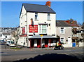
The Seabeach Swansea
Pub at 234 Oystermouth Road, on the corner of Burrows Road.
Image: © Jaggery
Taken: 26 Feb 2012
0.06 miles
4

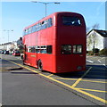
Routemaster bus in Swansea
This bus was one of several old-timers to be seen on the streets of Swansea today,
Sunday February 26th 2012. Passing the Seabeach pub http://www.geograph.org.uk/photo/3674180 on Oystermouth Road
is Routemaster RM308, part of the London Transport fleet from 1960 to 1985.
Image: © Jaggery
Taken: 26 Feb 2012
0.06 miles
5
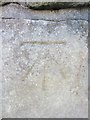
Ordnance Survey Cut Mark
This OS cut mark can be found on the wall of No27 Argyle Street. It marks a point 5.980m above mean sea level.
Image: © Adrian Dust
Taken: 19 Nov 2013
0.06 miles
6
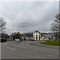
Argyle Street from the Civic Centre
Looking across Oystermouth Road into Sandfields from the road entrance to the Civic Centre. Mount Pleasant is visible in the distance on the right on the hillside, and part of Townhill in the centre on the top of the hill.
Image: © Z Pryce
Taken: 13 Apr 2022
0.06 miles
7

Sea Haven Hotel Swansea
The hotel with its distinctive six dormer windows is at 250 Oystermouth Road.
Image: © Jaggery
Taken: 26 Feb 2012
0.07 miles
8
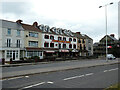
The Sea Haven Hotel, Oystermouth Road
No sign of life as I walked by in the early evening. A coronavirus victim, perhaps?
Image: © John Lucas
Taken: 20 Jun 2021
0.07 miles
9
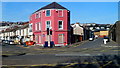
Conspicuous building on the corner of Argyle Street and Glamorgan Street, Swansea
Viewed across Oystermouth Road. Argyle Street is on the left side, and Glamorgan Street the right side, of the 3-storey building, which used to be the Glamorgan Arms pub. The skip on the pavement and boarded-up windows at the late February 2012 date of this view suggest alterations were taking place. A few weeks later, The Lock Up opened its doors here for the first time. At the right edge of the view is a wall of HM Prison Swansea...
Image: © Jaggery
Taken: 26 Feb 2012
0.07 miles
10
Preserved bus in Oystermouth Road Swansea
The preserved AEC Regent V/Willowbrook double-decker was as one of several old-timers to be seen on the streets of Swansea today, Sunday February 26th 2012.
Image: © Jaggery
Taken: 26 Feb 2012
0.07 miles