IMAGES TAKEN NEAR TO
Abercregan Road, PORT TALBOT, SA13 3LJ
Introduction
This page details the photographs taken nearby to Abercregan Road, SA13 3LJ by members of the Geograph project.
The Geograph project started in 2005 with the aim of publishing, organising and preserving representative images for every square kilometre of Great Britain, Ireland and the Isle of Man.

There are currently over 7.5m images from over14,400 individuals and you can help contribute to the project by visiting https://www.geograph.org.uk
Image Map
Images are licensed for reuse under creativecommons.org/licenses/by-sa/2.0
Notes
- Clicking on the map will re-center to the selected point.
- The higher the marker number, the further away the image location is from the centre of the postcode.
Image Listing (9 Images Found)
Images are licensed for reuse under creativecommons.org/licenses/by-sa/2.0
Image
Details
Distance
1
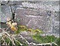
Ordnance Survey Cut Mark
This OS cut mark can be found on the wall of what was once the school. It marks a point 168.103m above mean sea level.
Image: © Adrian Dust
Taken: 8 Dec 2020
0.02 miles
2

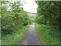
Footpath near Abercregan
The footpath here is narrow and a little overgrown, or will be soon.
Image: © Jeremy Bolwell
Taken: 24 Jun 2011
0.04 miles
3
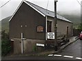
Polling Station
Abercregan polling station.
Image: © Alan Hughes
Taken: 8 Jun 2017
0.05 miles
4
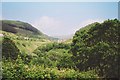
The valley of the Afan at Abercregan
Looking east up the valley of the River Afan at Abercregan towards Cymmer in the far distance. The photo was taken from the trackbed of the South Wales Mineral Railway which ran from Briton Ferry up the west side of the valley to Cymmer and then to Glyncorrwg. Another railway - the Rhondda & Swansea Bay - ran on the east side of the valley. Both have now become cycle paths. There is now very little sign that this valley was once full of mining activity.
Image: © Ron Strutt
Taken: Unknown
0.14 miles
5
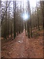
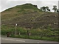
Forestry footpath
A narrow footpath winds through forestry commission land on Mynydd Rhywgregan. Many similar paths further up the mountain are currently closed as a lot of felling is taking place in this forest.
Image: © Hywel Williams
Taken: 3 Mar 2007
0.18 miles
6
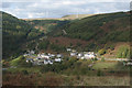
A view across the Afan Valley at Abercregan
A view over the former mining village from Pen-y-Castell, on the south side of the Afan Valley. The hillside with conifers seen in sunlight in the distance lies in the much smaller Cwm Cregan.
Image: © eswales
Taken: 16 Oct 2010
0.21 miles
7
Cycle path and former railway line near Cymmer
Image: © Gareth James
Taken: 23 Jun 2012
0.21 miles
8
Bus Stop at Pencastell
Bus stop on the main road at Pencastell near Cymmer.
Image: © Alan Hughes
Taken: 3 Jun 2017
0.22 miles
9

Approaching Abercregan grottos
The forestry track undulates as it approaches the grottos.
Image: © Jeremy Bolwell
Taken: 24 Jun 2011
0.25 miles