IMAGES TAKEN NEAR TO
Pentwyn Road, PORT TALBOT, SA13 3HH
Introduction
This page details the photographs taken nearby to Pentwyn Road, SA13 3HH by members of the Geograph project.
The Geograph project started in 2005 with the aim of publishing, organising and preserving representative images for every square kilometre of Great Britain, Ireland and the Isle of Man.

There are currently over 7.5m images from over14,400 individuals and you can help contribute to the project by visiting https://www.geograph.org.uk
Image Map (Loading...)


Getting Data...Please wait
Leaflet Map data © OpenStreetMap
Images are licensed for reuse under creativecommons.org/licenses/by-sa/2.0
Notes
- Clicking on the map will re-center to the selected point.
- The higher the marker number, the further away the image location is from the centre of the postcode.
Image Listing (11 Images Found)
Images are licensed for reuse under creativecommons.org/licenses/by-sa/2.0
Image
Details
Distance

2
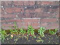
Ordnance Survey Cut Mark
This OS cut mark can be found on the wall of No3 Pentwyn Road. It marks a point 140.309m above mean sea level.
Image: © Adrian Dust
Taken: 19 May 2022
0.03 miles
3
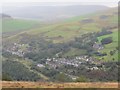
Cynonville
Edrych i lawr at bentre Cynonville yng Nghwm Afan. Yn sgil cwympo'r blanhigfa goniferaidd mae'r olygfa hon unwaith eto i'w mwynhau.
Looking down on the village of Cynonville in the Afan Valley. Prior to the felling of the coniferous plantation this view has not been possible for many a year.
Image: © Alan Richards
Taken: 16 Sep 2012
0.04 miles
4
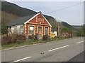
Tabernacl y Bedyddwyr
Disused Welsh chapel on the outskirts of Cynonville awaiting demolition.
Image: © Alan Hughes
Taken: 18 Apr 2019
0.14 miles
5

Ordnance Survey Cut Mark
This OS cut mark can be found on the SW angle of the Baptist Chapel. It marks a point 133.149m above mean sea level.
Image: © Adrian Dust
Taken: 19 May 2022
0.14 miles
6
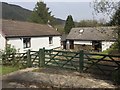
Ty Canol
Farm accommodation in Afan Forest Park.
Image: © Alan Hughes
Taken: 18 Apr 2019
0.20 miles
7
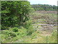
Mixed woodland in the Afan Forest Park
Taken from the old railway trackbed, which is now a cycleway and path through the valley. The forestry plantation is being harvested to the right and adjacent are deciduous woodlands.
Image: © Jeremy Bolwell
Taken: 3 Jul 2011
0.22 miles
8
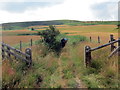
Uwchben Afan Argoed / Above Afan Argoed
Heol las uwchben Afan Argoed. Dyma'r ffordd hefyd y daw Llwybr Sant Illtyd.
A green lane above Afan Argoed. The St Illtyd's Way also comes this way.
Image: © Alan Richards
Taken: 14 Jul 2019
0.23 miles
9
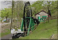
Mining machinery at Afan Argoed Miners' Museum
The item in the foreground is a drill which was used to locate pockets of methane gas.
Image: © john bristow
Taken: 20 May 2013
0.24 miles
10
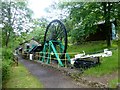
Afan Argoed Miners' Museum
Afan Argoed Miners' Museum is found in Afan Argoed Country Park where it cost £1.00 to park. There are walks, mountain bike tracks and a great cafe.
Image: © Rude Health
Taken: 2 Jul 2015
0.24 miles