IMAGES TAKEN NEAR TO
Brytwn Road, PORT TALBOT, SA13 3EW
Introduction
This page details the photographs taken nearby to Brytwn Road, SA13 3EW by members of the Geograph project.
The Geograph project started in 2005 with the aim of publishing, organising and preserving representative images for every square kilometre of Great Britain, Ireland and the Isle of Man.

There are currently over 7.5m images from over14,400 individuals and you can help contribute to the project by visiting https://www.geograph.org.uk
Image Map (Loading...)


Getting Data...Please wait
Leaflet Map data © OpenStreetMap
Images are licensed for reuse under creativecommons.org/licenses/by-sa/2.0
Notes
- Clicking on the map will re-center to the selected point.
- The higher the marker number, the further away the image location is from the centre of the postcode.
Image Listing (148 Images Found)
Images are licensed for reuse under creativecommons.org/licenses/by-sa/2.0
Image
Details
Distance
1
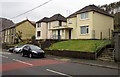
Cymmer Police Station
Viewed across the A4107 Brytwn Road. Cymmer is part of the Western Division of South Wales Police.
As well as Cymmer, the station's area includes the villages of Cynonville, Duffryn Rhondda, Abercregan and Croeserw.
Image: © Jaggery
Taken: 18 Feb 2015
0.01 miles
2
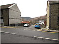
SW end of Margam Street, Cymmer
Viewed across the A4107 Brytwn Road.
Image: © Jaggery
Taken: 18 Feb 2015
0.02 miles
3
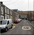
Slow down - bend ahead on Brytwn Road, Cymmer
The A4107 Brytwn Road SW of the Margam Street junction.
Image: © Jaggery
Taken: 18 Feb 2015
0.03 miles
4
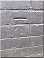
Ordnance Survey Cut Mark
This OS cut mark can be found on No64 Brytwn Road. It marks a point 188.757m above mean sea level.
Image: © Adrian Dust
Taken: 12 Apr 2015
0.03 miles
5
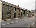
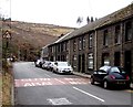
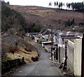
Long row of houses, Brytwn Road, Cymmer
Extending for about 75 metres.
Image: © Jaggery
Taken: 18 Feb 2015
0.04 miles
6
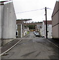
Up Glenavon Street, Cymmer
Glenavon Street ascends from the valley of the Afon Afan, past the Maesteg Street intersection, towards the A4107 Brytwn Road.
Image: © Jaggery
Taken: 18 Feb 2015
0.04 miles
7
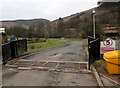
Grid across the entrance to Cymer Afan Primary School, Cymmer
From Margam Street. The school is on a flat site on the south bank of a river, the Afon Afan.
Image: © Jaggery
Taken: 18 Feb 2015
0.04 miles
8
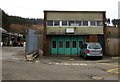
Former ambulance station in Cymmer
Still showing CYMMER AMBULANCE STATION in February 2015, this Margam Street
building is the former ambulance station, which is now in a building on the fire station site. http://www.geograph.org.uk/photo/4355931
Image: © Jaggery
Taken: 18 Feb 2015
0.04 miles
9
20 on Margam Street, Cymmer
Maximum speed 20mph on the approach to the entrance http://www.geograph.org.uk/photo/4356931 to Cymer Afan Primary School.
The green doors in the distance are part of the former Ambulance Station. http://www.geograph.org.uk/photo/4355928
Image: © Jaggery
Taken: 18 Feb 2015
0.04 miles
10
Lane west of Cymer Afan Comprehensive School, Cymmer
The lane is part of National Cycle Network Route 885.
Image: © Jaggery
Taken: 18 Feb 2015
0.05 miles