IMAGES TAKEN NEAR TO
Matthews Street, PORT TALBOT, SA13 3BD
Introduction
This page details the photographs taken nearby to Matthews Street, SA13 3BD by members of the Geograph project.
The Geograph project started in 2005 with the aim of publishing, organising and preserving representative images for every square kilometre of Great Britain, Ireland and the Isle of Man.

There are currently over 7.5m images from over14,400 individuals and you can help contribute to the project by visiting https://www.geograph.org.uk
Image Map (Loading...)


Getting Data...Please wait
Leaflet Map data © OpenStreetMap
Images are licensed for reuse under creativecommons.org/licenses/by-sa/2.0
Notes
- Clicking on the map will re-center to the selected point.
- The higher the marker number, the further away the image location is from the centre of the postcode.
Image Listing (44 Images Found)
Images are licensed for reuse under creativecommons.org/licenses/by-sa/2.0
Image
Details
Distance
1

Bible Christian Chapel
Immediately adjacent to Glyncorrwg United Methodist Chapel.
See https://neathporttalbotmethodist.org.uk/glyncorrwg-methodist-church/
Image: © Alan Hughes
Taken: 21 Aug 2024
0.02 miles
2
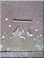
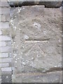
Ordnance Survey Cut Mark
This OS cut mark can be found on the post of the chapel on Bryn Road. It marks a point 231.666m above mean sea level.
Image: © Adrian Dust
Taken: 12 Apr 2015
0.03 miles
3
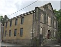
Calfaria Baptist Chapel
Calfaria Baptist Chapel, Glyncorrwg - now disused.
Image: © Alan Hughes
Taken: 3 Jun 2017
0.05 miles
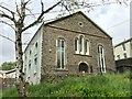
4

Nebo Independent Chapel, Glyncorrwg
First built in 1861, this chapel was once ornately decorated with integrated columns and pilasters, triangular pediments to the upper windows, a large keystone to the central windows, heavily decorated with foliage designs, and a segmental pediment with similar decoration. The paler stonework shows where this was all stripped off during the 20th century. By 2000 Nebo had fallen into disuse.
Image: © Alan Hughes
Taken: 21 Aug 2024
0.06 miles


7
Carmel Methodist Chapel, Glyncorrwg
This chapel was built in 1875 and restored in 1930.
Image: © Alan Hughes
Taken: 3 Jun 2017
0.07 miles
8
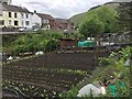
Glyncorrwg Allotments
Well-tended allotments opposite terraced houses in Glyncorrwg.
Image: © Alan Hughes
Taken: 3 Jun 2017
0.08 miles
9
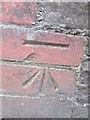
Ordnance Survey Cut Mark
This OS cut mark can be found on the north angle of the school. It marks a point 219.953m above mean sea level.
Image: © Adrian Dust
Taken: 12 Apr 2015
0.09 miles
10
Ordnance Survey Cut Mark
This OS cut mark can be found on the gatepost of No4 Cymmer Road. It marks a point 229.015m above mean sea level.
Image: © Adrian Dust
Taken: 12 Apr 2015
0.09 miles