IMAGES TAKEN NEAR TO
Bridge Street, PORT TALBOT, SA13 3BA
Introduction
This page details the photographs taken nearby to Bridge Street, SA13 3BA by members of the Geograph project.
The Geograph project started in 2005 with the aim of publishing, organising and preserving representative images for every square kilometre of Great Britain, Ireland and the Isle of Man.

There are currently over 7.5m images from over14,400 individuals and you can help contribute to the project by visiting https://www.geograph.org.uk
Image Map
Images are licensed for reuse under creativecommons.org/licenses/by-sa/2.0
Notes
- Clicking on the map will re-center to the selected point.
- The higher the marker number, the further away the image location is from the centre of the postcode.
Image Listing (45 Images Found)
Images are licensed for reuse under creativecommons.org/licenses/by-sa/2.0
Image
Details
Distance
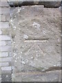
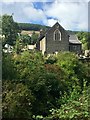
1
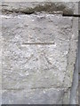
Ordnance Survey Cut Mark
This OS cut mark can be found on the NE parapet of the bridge over the Afon Corrwg. It marks a point 218.502m above mean sea level.
Image: © Adrian Dust
Taken: 12 Apr 2015
0.01 miles
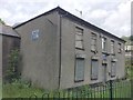
2
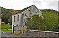
The derelict Station Master's house - Glyncorrwg
I am led to believe that many years ago a railway line served the village. Although primarily a goods line related to the local mining industry it also un-officially carried passengers. The latter practice was dis-continued after an accident involving a passenger.
Image: © Mick Lobb
Taken: 21 Sep 2009
0.01 miles
3
Half a house on Commercial Street - Glyncorrwg
The shape of the house was determined by its previous incarnation as a corner shop.
Image: © Mick Lobb
Taken: 21 Sep 2009
0.02 miles
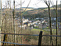
4

Part of Glyncorrwg viewed from Queen Street
The village seems a proper community and although some of its buildings, such as the chapels, have maybe seen their glory days, there is evidence of new developments and the place is certainly not looking back, but forward.
Image: © Jeremy Bolwell
Taken: 24 Jun 2011
0.03 miles
5
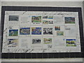
Wall mural in Glyncorrwg
This excellent mural depicts the history of the village and its inhabitants.
Image: © Jeremy Bolwell
Taken: 24 Jun 2011
0.04 miles
6
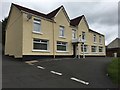
The Queens B&B, Glyncorrwg
A small B&B catering for the tourist in the Glyncorrwg area.
Image: © Alan Hughes
Taken: 3 Jun 2017
0.04 miles
7
Ordnance Survey Cut Mark
This OS cut mark can be found on the north angle of the school. It marks a point 219.953m above mean sea level.
Image: © Adrian Dust
Taken: 12 Apr 2015
0.06 miles
8
Looking down on Glyncorrwg from Pleasant View
Image: © Nick Smith
Taken: 13 Jan 2012
0.06 miles
9
Glyncorrwg Conservative Club
Taken five days before the 2017 general election, this photograph will do nothing to raise Mrs May's hopes - at least in Glyncorrwg!
Image: © Alan Hughes
Taken: 3 Jun 2017
0.06 miles
10
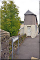
Glyncorrwg Church
Church of St John the Baptist, Glyncorrwg.
Image: © Alan Hughes
Taken: 1 Sep 2019
0.08 miles