IMAGES TAKEN NEAR TO
Goytre, PORT TALBOT, SA13 2YF
Introduction
This page details the photographs taken nearby to SA13 2YF by members of the Geograph project.
The Geograph project started in 2005 with the aim of publishing, organising and preserving representative images for every square kilometre of Great Britain, Ireland and the Isle of Man.

There are currently over 7.5m images from over14,400 individuals and you can help contribute to the project by visiting https://www.geograph.org.uk
Image Map (Loading...)


Getting Data...Please wait
Leaflet Map data © OpenStreetMap
Images are licensed for reuse under creativecommons.org/licenses/by-sa/2.0
Notes
- Clicking on the map will re-center to the selected point.
- The higher the marker number, the further away the image location is from the centre of the postcode.
Image Listing (10 Images Found)
Images are licensed for reuse under creativecommons.org/licenses/by-sa/2.0
Image
Details
Distance
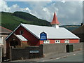
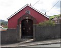
1
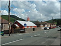
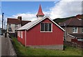
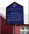
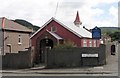
St Peters, Goytre
Looking NE near centre of square
Image: © Chris Shaw
Taken: Unknown
0.11 miles
3
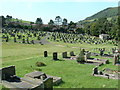
Goytre Cemetery
Just part of the extensive cemetery to the East of the village
Image: © Chris Shaw
Taken: Unknown
0.11 miles
4
Neath Port Talbot : Goytre Scenery
Looking down to the Goytre area of Port Talbot.
Image: © Lewis Clarke
Taken: 13 Aug 2017
0.20 miles
5
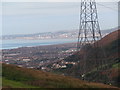
Port Talbot
Port Talbot & Bae Abertawe o'r Goetre
Port Tabot & Swansea Bay from Goetre
Image: © Alan Richards
Taken: 17 Oct 2010
0.21 miles
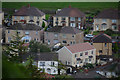
10
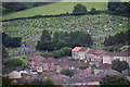
Neath Port Talbot : Goytre Scenery
Looking across to houses and the cemetery outside of Port Talbot.
Image: © Lewis Clarke
Taken: 13 Aug 2017
0.25 miles