IMAGES TAKEN NEAR TO
Nant Y Wiwer, PORT TALBOT, SA13 2XX
Introduction
This page details the photographs taken nearby to Nant Y Wiwer, SA13 2XX by members of the Geograph project.
The Geograph project started in 2005 with the aim of publishing, organising and preserving representative images for every square kilometre of Great Britain, Ireland and the Isle of Man.

There are currently over 7.5m images from over14,400 individuals and you can help contribute to the project by visiting https://www.geograph.org.uk
Image Map (Loading...)


Getting Data...Please wait
Leaflet Map data © OpenStreetMap
Images are licensed for reuse under creativecommons.org/licenses/by-sa/2.0
Notes
- Clicking on the map will re-center to the selected point.
- The higher the marker number, the further away the image location is from the centre of the postcode.
Image Listing (7 Images Found)
Images are licensed for reuse under creativecommons.org/licenses/by-sa/2.0
Image
Details
Distance
1

New Housing Estate
Housing at Llwyn Arian, Coed Hirwaun, near Pyle.
Image: © Alan Hughes
Taken: 22 Mar 2017
0.13 miles
2
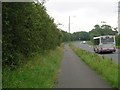
A48 near Coedhirwaun
Looking south towards Pyle. National Cycle Route 4 runs alongside the main road here, between Pyle and Margam.
Image: © Simon Mortimer
Taken: 9 Aug 2012
0.18 miles
3
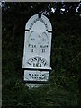
Milepost on A48 west of Pyle.
One of a series of mileposts along the A48 Cardiff to Swansea road; now well restored but leaning a little.
Image: © Colin Pyle
Taken: 1 Sep 2009
0.20 miles
4
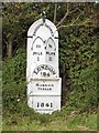
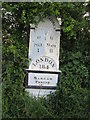
Old Milepost by the A48, southwest of Coedhirwaun, Margam parish
Glamorgan Gothic casting by the A48, in parish of Margam (Neath Port Talbot District), Cae Garw; Southwest of Coedhirwaun, on grass verge in front of hedge, Northeast side of road.
Inscription reads:-
: PYLE / 1 : : BRIDGEND / DISTRICT : : TO / NEATH / 11 :
: LONDON / 184 / MARGAM / PARISH / 1841 :
Grade II listed by Cadw.
Reference Number: 23287 https://cadwpublic-api.azurewebsites.net/reports/listedbuilding/FullReport?lang=&id=23287
Surveyed
Milestone Society National ID: GLA_184PYNT01
Image: © Milestone Society
Taken: Unknown
0.20 miles
5
Mile Post - Neath 11
NE side of the road.
Image: © Adrian Dust
Taken: 4 May 2015
0.20 miles
6
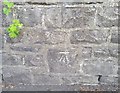
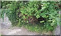
Ordnance Survey Cut Mark
This OS cut mark can be found on the wall SW side of the road. It marks a point 51.773m above mean sea level.
Image: © Adrian Dust
Taken: 9 Jun 2020
0.23 miles