IMAGES TAKEN NEAR TO
Llwyn Arian, PORT TALBOT, SA13 2UP
Introduction
This page details the photographs taken nearby to Llwyn Arian, SA13 2UP by members of the Geograph project.
The Geograph project started in 2005 with the aim of publishing, organising and preserving representative images for every square kilometre of Great Britain, Ireland and the Isle of Man.

There are currently over 7.5m images from over14,400 individuals and you can help contribute to the project by visiting https://www.geograph.org.uk
Image Map
Images are licensed for reuse under creativecommons.org/licenses/by-sa/2.0
Notes
- Clicking on the map will re-center to the selected point.
- The higher the marker number, the further away the image location is from the centre of the postcode.
Image Listing (2 Images Found)
Images are licensed for reuse under creativecommons.org/licenses/by-sa/2.0
Image
Details
Distance
1

New Housing Estate
Housing at Llwyn Arian, Coed Hirwaun, near Pyle.
Image: © Alan Hughes
Taken: 22 Mar 2017
0.02 miles
2
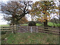
Llwybr Hirwaun / Hirwaun path
Llwybr troed cyhoeddus yn mynd i gyfeiriad anhedd-dy o'r enw Hirwaun.
A public footpath heading in the direction of a property known as Hirwaun (trans. long low marshy ground / meadow).
Image: © Alan Richards
Taken: 15 Nov 2023
0.19 miles