IMAGES TAKEN NEAR TO
Eglwys Nunnydd, PORT TALBOT, SA13 2PS
Introduction
This page details the photographs taken nearby to Eglwys Nunnydd, SA13 2PS by members of the Geograph project.
The Geograph project started in 2005 with the aim of publishing, organising and preserving representative images for every square kilometre of Great Britain, Ireland and the Isle of Man.

There are currently over 7.5m images from over14,400 individuals and you can help contribute to the project by visiting https://www.geograph.org.uk
Image Map (Loading...)


Getting Data...Please wait
Leaflet Map data © OpenStreetMap
Images are licensed for reuse under creativecommons.org/licenses/by-sa/2.0
Notes
- Clicking on the map will re-center to the selected point.
- The higher the marker number, the further away the image location is from the centre of the postcode.
Image Listing (18 Images Found)
Images are licensed for reuse under creativecommons.org/licenses/by-sa/2.0
Image
Details
Distance
1
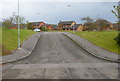
Entrance to Eglwys Nunydd near Margam
Viewed across Water Street (B4283). Eglwys Nunydd is a cul-de-sac of modern houses.
Image: © Jaggery
Taken: 19 Apr 2012
0.06 miles
2
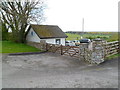
Converted farm buildings, Eglwys Nunydd
Some houses in this part of Eglwys Nunydd are converted former farm buildings, with names such as Old Forge, The Granary and Water Mill.
Image: © Jaggery
Taken: 19 Apr 2012
0.09 miles
3
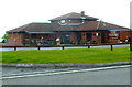
The Grand Sultan
Indian restaurant at the Lakeside Golf course in Margam,
Image: © Eirian Evans
Taken: 25 May 2021
0.10 miles
4
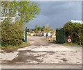
Entrance to Afan Landscapes near Margam
Viewed across Water Street (B4283). Afan Landscapes provide all aspects of landscaping, including design, maintenance, construction, irrigation, stonewalls, outdoor rooms, water features and lighting for commercial clients.
Image: © Jaggery
Taken: 19 Apr 2012
0.14 miles
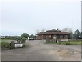
5
The Priory at Lakeside near Margam
Restaurant in Water Street at the edge of the Lakeside golf course.
Image: © Jaggery
Taken: 19 Apr 2012
0.14 miles
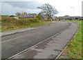
6
Eastern edge of Lakeside golf course near Margam
Viewed from Water Street (B4283).
Image: © Jaggery
Taken: 19 Apr 2012
0.15 miles
7
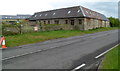
Converted barn, Eglwys Nunydd near Margam
Now a residential property, this was formerly a farm building.
Image: © Jaggery
Taken: 19 Apr 2012
0.15 miles
8
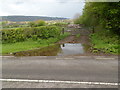
Large puddle in front of a field gate south of Cwrt-y-defaid
A watery approach to a field gate viewed across Water Street (B4283).
Image: © Jaggery
Taken: 19 Apr 2012
0.17 miles
9
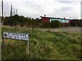
Golf Driving Range
Golf driving range at St.Davids Parc.
Image: © Alan Hughes
Taken: 8 Nov 2016
0.17 miles
10

Golf driving range and Booth's Cafe near Margam
On the corner of Water Street and St David's Park, near the Lakeside Golf Club.
Booth's Cafe http://www.geograph.org.uk/photo/2994752 is on the right - a white van is parked in front of it.
Image: © Jaggery
Taken: 19 Apr 2012
0.19 miles