IMAGES TAKEN NEAR TO
Margam Road, PORT TALBOT, SA13 2HR
Introduction
This page details the photographs taken nearby to Margam Road, SA13 2HR by members of the Geograph project.
The Geograph project started in 2005 with the aim of publishing, organising and preserving representative images for every square kilometre of Great Britain, Ireland and the Isle of Man.

There are currently over 7.5m images from over14,400 individuals and you can help contribute to the project by visiting https://www.geograph.org.uk
Image Map (Loading...)


Getting Data...Please wait
Leaflet Map data © OpenStreetMap
Images are licensed for reuse under creativecommons.org/licenses/by-sa/2.0
Notes
- Clicking on the map will re-center to the selected point.
- The higher the marker number, the further away the image location is from the centre of the postcode.
Image Listing (31 Images Found)
Images are licensed for reuse under creativecommons.org/licenses/by-sa/2.0
Image
Details
Distance
1
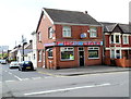
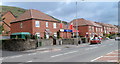
Margam Fish Bar, Port Talbot
On the corner of Margam Road and Brombil Street, Margam.
Image: © Jaggery
Taken: 19 Apr 2012
0.05 miles
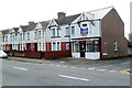
2
Glanafan Court Funeral Home, Margam, Port Talbot
The Condon Funeral Service building is on the corner of Margam Road and Prince Street.
Image: © Jaggery
Taken: 19 Apr 2012
0.09 miles
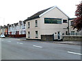
3

Margam Road Evangelical Church, Margam, Port Talbot
Located on the SW side of Margam Road (the A48). The back of the church is adjacent to Duke Street.
Image: © Jaggery
Taken: 19 Apr 2012
0.09 miles
4
J C Motorcycles Margam
Shop at 52 Margam Road, on the corner of Prince Street.
Image: © Jaggery
Taken: 19 Apr 2012
0.10 miles
5

Margam Mini-Market
General stores and off-licence in Margam Road, near the corner of Donnen Street.
Image: © Jaggery
Taken: 19 Apr 2012
0.10 miles
6

Our Lady of Margam RC church, Port Talbot
Roman Catholic church on the NE side of Margam Road (the A48).
Image: © Jaggery
Taken: 19 Apr 2012
0.10 miles
7
Parc Groeswen houses, Margam, Port Talbot
Recently-built houses alongside Margam Road (the A48).
Image: © Jaggery
Taken: 19 Apr 2012
0.10 miles
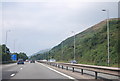
8
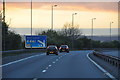
Neath Port Talbot : M4 Motorway
Heading through the Neath Port Talbot area westbound on the M4 Motorway.
Image: © Lewis Clarke
Taken: 10 Apr 2014
0.12 miles
9
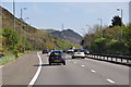
Neath Port Talbot : M4 Motorway
The M4 Motorway heading eastbound as it passes through Neath Port Talbot.
Image: © Lewis Clarke
Taken: 11 Apr 2014
0.12 miles