IMAGES TAKEN NEAR TO
Heol Yr Orsedd, PORT TALBOT, SA13 2HL
Introduction
This page details the photographs taken nearby to Heol Yr Orsedd, SA13 2HL by members of the Geograph project.
The Geograph project started in 2005 with the aim of publishing, organising and preserving representative images for every square kilometre of Great Britain, Ireland and the Isle of Man.

There are currently over 7.5m images from over14,400 individuals and you can help contribute to the project by visiting https://www.geograph.org.uk
Image Map
Images are licensed for reuse under creativecommons.org/licenses/by-sa/2.0
Notes
- Clicking on the map will re-center to the selected point.
- The higher the marker number, the further away the image location is from the centre of the postcode.
Image Listing (63 Images Found)
Images are licensed for reuse under creativecommons.org/licenses/by-sa/2.0
Image
Details
Distance
1
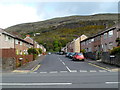
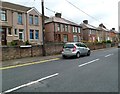
Heol Yr Orsedd, Margam, Port Talbot
Viewed from Margam Road (the A48). The M4 motorway is about 60 metres beyond the far end of the street.
Image: © Jaggery
Taken: 19 Apr 2012
0.02 miles
2
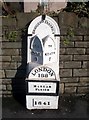
Old Milestone by the A48, Margam Road, Tai Bach Parish
Glamorgan Gothic by the A48, in parish of Tai Bach (Neath Port Talbot District), Margam Road; junction with Heol yr Orsedd, on pavement, North East side of road.
Inscription reads:-
: TO / PYLE / 5 : : BRIDGEND DISTRICT : : TO / NEATH / 7 : : LONDON / 188 / MARGAM / PARISH / 1841 :
Grade II Listed by Cadw.
Reference Number 22808: https://cadwpublic-api.azurewebsites.net/reports/listedbuilding/FullReport?lang=&id=22808
Surveyed
Milestone Society National ID: GLA_188PYNT05
Image: © Milestone Society
Taken: Unknown
0.05 miles
3
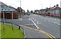
NW boundary of Margam, Port Talbot
Looking along the A48, which is renamed from Commercial Road, Taibach behind the camera to Margam Road, Margam ahead. The left turn is the Constant Road junction.
Image: © Jaggery
Taken: 19 Apr 2012
0.06 miles
4

Ordnance Survey Cut Mark
This OS cut mark can be found on the former Youth Centre. It marks a point 7.376m above mean sea level.
Image: © Adrian Dust
Taken: 6 May 2020
0.06 miles
5

Wood Street, Margam, Port Talbot
Viewed from Margam Road (the A48).
Image: © Jaggery
Taken: 19 Apr 2012
0.07 miles
6

Port Talbot : The M4 Motorway
The M4 Motorway heading through the South Wales landscape.
Image: © Lewis Clarke
Taken: 23 Mar 2014
0.10 miles
7

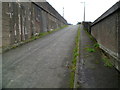
Taibach Community Education Centre, Port Talbot
Located on the SW side of the A48, at the boundary between the suburbs of Taibach and Margam. Formerly known as Eastern County School, the centre is well used by the local community and voluntary groups, who hire rooms for meetings, training etc. Adult Education classes here are popular.
Image: © Jaggery
Taken: 19 Apr 2012
0.10 miles
8

A48 milestone near the corner of Heol Yr Orsedd, Margam, Port Talbot
The milestone shows
BRIDGEND DISTRICT
TO PYLE 5
TO NEATH 7
LONDON 188
MARGAM PARISH
1841
The milestone is in very good condition, so perhaps it is a facsimile of the original.
Image: © Jaggery
Taken: 19 Apr 2012
0.10 miles
9
Steep ascent from M4 subway, Taibach, Port Talbot
Inkerman Row climbs away from a subway http://www.geograph.org.uk/photo/2949265 under the M4 motorway.
Image: © Jaggery
Taken: 19 Apr 2012
0.10 miles
10
Constant Road, Taibach, Port Talbot
Houses on the east side of the road, viewed from the Incline Row end.
Image: © Jaggery
Taken: 19 Apr 2012
0.10 miles