IMAGES TAKEN NEAR TO
Min-y-Don, PORT TALBOT, SA13 2DX
Introduction
This page details the photographs taken nearby to Min-y-Don, SA13 2DX by members of the Geograph project.
The Geograph project started in 2005 with the aim of publishing, organising and preserving representative images for every square kilometre of Great Britain, Ireland and the Isle of Man.

There are currently over 7.5m images from over14,400 individuals and you can help contribute to the project by visiting https://www.geograph.org.uk
Image Map
Images are licensed for reuse under creativecommons.org/licenses/by-sa/2.0
Notes
- Clicking on the map will re-center to the selected point.
- The higher the marker number, the further away the image location is from the centre of the postcode.
Image Listing (19 Images Found)
Images are licensed for reuse under creativecommons.org/licenses/by-sa/2.0
Image
Details
Distance
1
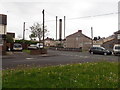
Junction of Brynhyfryd Road and Morfa Road, Margam
Image: © Eirian Evans
Taken: 6 May 2019
0.03 miles
2
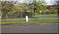
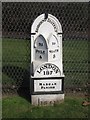
Milestone, Tollgate Road, Margam, Port Talbot
Located at the edge of Tollgate Park, the milestone shows
BRIDGEND DISTRICT
TO PYLE 4
TO NEATH 8
LONDON 187
MARGAM PARISH
1841
Image: © Jaggery
Taken: 19 Apr 2012
0.09 miles
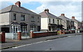
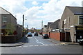
3
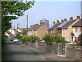
Houses on Brynhyfryd, Margam
Looking west towards the steel works. The road forms part of National Cycle Route 4.
Image: © Simon Mortimer
Taken: 9 Aug 2012
0.10 miles
4
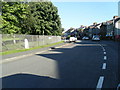
Tollgate Road
Cast iron milepost is on the left
Image: © Colin Pyle
Taken: 30 Aug 2010
0.13 miles
5
Old Milestone by the former A48, Tollgate Road in Margam
Glamorgan Gothic by the former A48, in parish of Margam (Neath Port Talbot District), Tollgate Road; outside Tollgate Park, against boundary fence.
Inscription reads:-
: TO / PYLE / 4 : : BRIDGEND DISTRICT : : TO / NEATH / 8 : : LONDON / 187 / MARGAM / PARISH / 1841 :
Grade II listed by Cadw.
Reference Number: 23284 https://cadwpublic-api.azurewebsites.net/reports/listedbuilding/FullReport?lang=&id=23284
Surveyed
Milestone Society National ID: GLA_187PYNT04
Image: © Milestone Society
Taken: Unknown
0.13 miles
6
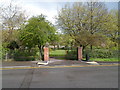
An entrance to Tollgate Park, Margam, Port Talbot
Viewed across Tollgate Road, near the Morfa Road junction.
Image: © Jaggery
Taken: 19 Apr 2012
0.13 miles
7
Tollgate Road houses, Margam, Port Talbot
The houses face Tollgate Park, between Morfa Road and Maximin Road.
Image: © Jaggery
Taken: 19 Apr 2012
0.13 miles
8
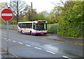
Terminus of bus route 8, Margam, Port Talbot
A First bus, fleet number P41726, waits at a bus stop at the eastern end of Tollgate Road.
This is the terminus of route 8 from Port Talbot bus station http://www.geograph.org.uk/photo/2830101 via the town centre and Taibach.
Image: © Jaggery
Taken: 19 Apr 2012
0.14 miles
9
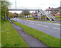
Margam Road footbridge, Margam, Port Talbot
The footbridge across the A48 leads to Beechwood Road.
Image: © Jaggery
Taken: 19 Apr 2012
0.14 miles
10
Maximin Road, Margam, Port Talbot
Viewed from the edge of Tollgate Park. This curiously-named road appears to be
the only Maximin in the UK. Morgan's Barber Shop http://www.geograph.org.uk/photo/2950568 is on the right.
Image: © Jaggery
Taken: 19 Apr 2012
0.15 miles