IMAGES TAKEN NEAR TO
Bertha Road, PORT TALBOT, SA13 2AP
Introduction
This page details the photographs taken nearby to Bertha Road, SA13 2AP by members of the Geograph project.
The Geograph project started in 2005 with the aim of publishing, organising and preserving representative images for every square kilometre of Great Britain, Ireland and the Isle of Man.

There are currently over 7.5m images from over14,400 individuals and you can help contribute to the project by visiting https://www.geograph.org.uk
Image Map
Images are licensed for reuse under creativecommons.org/licenses/by-sa/2.0
Notes
- Clicking on the map will re-center to the selected point.
- The higher the marker number, the further away the image location is from the centre of the postcode.
Image Listing (28 Images Found)
Images are licensed for reuse under creativecommons.org/licenses/by-sa/2.0
Image
Details
Distance
1
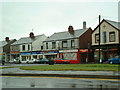
Margam Shops
Looking SW near centre of grid square
Image: © Chris Shaw
Taken: Unknown
0.04 miles
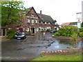
2
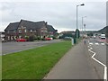
The Twelve Knights
On the A48 at Margam, Port Talbot, The Twelve Knights.
Image: © Alan Hughes
Taken: 20 Jul 2017
0.07 miles
3
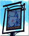
The Twelve Knights pub sign, Margam, Port Talbot
The Age of Austerity, with cutbacks in many areas, appears to have reached even pub signs, judging by this single representative of the Twelve Knights in the sign outside the Margam Road pub. http://www.geograph.org.uk/photo/2950537
Image: © Jaggery
Taken: 19 Apr 2012
0.11 miles
4
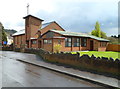
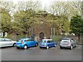
St David's Church, Margam, Port Talbot
Located in Ty Fry Road, opposite the Wern Road junction. http://www.geograph.org.uk/photo/2950528
The Church in Wales church is in the parish of Margam, part of the archdeaconry of Margam in the diocese of Llandaff.
Image: © Jaggery
Taken: 19 Apr 2012
0.11 miles
5

Ordnance Survey Cut Mark
This OS cut mark can be found on the wall of No282 Tollgate Road. It marks a point 8.080m above mean sea level.
Image: © Adrian Dust
Taken: 6 May 2020
0.13 miles
6
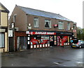
Post office inside a Bargain Booze shop, Margam, Port Talbot
Located at 260 Margam Road, previously Tollgate Post Office & Convenience Store.
Image: © Jaggery
Taken: 19 Apr 2012
0.14 miles
7
Beulah chapel, Margam, Port Talbot
Located in the northern corner of Tollgate Park. A small oval plaque on the wall records that Beulah Calvinistic Methodist Chapel, built at Groes in 1838, was dismantled and rebuilt here in 1976.
The name board shows EGLWYS BRESBYTERIADD CYMRU (Presbyterian Church of Wales) BEULAH.
Image: © Jaggery
Taken: 19 Apr 2012
0.14 miles
8
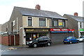
Morgan's Barber Shop, Margam, Port Talbot
Located at 282 Margam Road, on the corner of Maximin Road.
Next door, there is a For Sale sign on the closed Tredwell Carpets shop.
Image: © Jaggery
Taken: 19 Apr 2012
0.14 miles
9
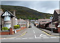
Stallcourt Road, Margam, Port Talbot
Viewed from Margam Road (the A48).
Image: © Jaggery
Taken: 19 Apr 2012
0.16 miles
10
The Twelve Knights, Margam, Port Talbot
Pub with 11 guest bedrooms and a large function room.
Located on the west side of Margam Road (the A48).
Image: © Jaggery
Taken: 19 Apr 2012
0.17 miles