IMAGES TAKEN NEAR TO
Somerset Street, PORT TALBOT, SA13 1UA
Introduction
This page details the photographs taken nearby to Somerset Street, SA13 1UA by members of the Geograph project.
The Geograph project started in 2005 with the aim of publishing, organising and preserving representative images for every square kilometre of Great Britain, Ireland and the Isle of Man.

There are currently over 7.5m images from over14,400 individuals and you can help contribute to the project by visiting https://www.geograph.org.uk
Image Map (Loading...)


Getting Data...Please wait
Leaflet Map data © OpenStreetMap
Images are licensed for reuse under creativecommons.org/licenses/by-sa/2.0
Notes
- Clicking on the map will re-center to the selected point.
- The higher the marker number, the further away the image location is from the centre of the postcode.
Image Listing (76 Images Found)
Images are licensed for reuse under creativecommons.org/licenses/by-sa/2.0
Image
Details
Distance
1
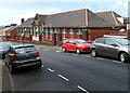
Eastern Primary School, Taibach, Port Talbot
Viewed across Incline Row.
Image: © Jaggery
Taken: 19 Apr 2012
0.03 miles
2
Incline Row, Taibach, Port Talbot
Incline Row climbs away from Commercial Road (the A48).
Image: © Jaggery
Taken: 19 Apr 2012
0.03 miles
3

Early Years Unit, Eastern Primary School, Taibach, Port Talbot
Viewed across Incline Row. The Early Years Unit is at the eastern edge of the school. http://www.geograph.org.uk/photo/2949307
Image: © Jaggery
Taken: 19 Apr 2012
0.03 miles
4
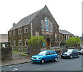
Taibach Methodist Church, Port Talbot
Located in Incline Row. The church is an 1892 rebuild of the 1840 original.
Image: © Jaggery
Taken: 19 Apr 2012
0.03 miles
5
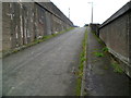
Steep ascent from M4 subway, Taibach, Port Talbot
Inkerman Row climbs away from a subway http://www.geograph.org.uk/photo/2949265 under the M4 motorway.
Image: © Jaggery
Taken: 19 Apr 2012
0.06 miles
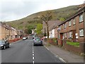
6
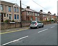
Constant Road, Taibach, Port Talbot
Houses on the east side of the road, viewed from the Incline Row end.
Image: © Jaggery
Taken: 19 Apr 2012
0.06 miles
7

Ordnance Survey Cut Mark
This OS cut mark can be found on the SE parapet of the railway bridge. It marks a point 19.303m above mean sea level.
Image: © Adrian Dust
Taken: 6 May 2020
0.07 miles
8
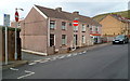
Waterfall Cottages, Taibach, Port Talbot
Waterfall Cottages are a separately-named section of Incline Row.
Image: © Jaggery
Taken: 19 Apr 2012
0.08 miles
9
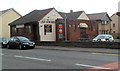
The Old Surgery, Taibach, Port Talbot
Commercial Road pub, located opposite the Incline Row junction.
Image: © Jaggery
Taken: 19 Apr 2012
0.08 miles
10
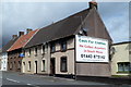
Prominent advertising for a nearby shop, Taibach, Port Talbot
The board on the side of a row of houses adjacent to the Somerset Arms http://www.geograph.org.uk/photo/2939374 is for a local shop. http://www.geograph.org.uk/photo/2939000
Image: © Jaggery
Taken: 19 Apr 2012
0.08 miles