IMAGES TAKEN NEAR TO
Brook Street, PORT TALBOT, SA13 1TG
Introduction
This page details the photographs taken nearby to Brook Street, SA13 1TG by members of the Geograph project.
The Geograph project started in 2005 with the aim of publishing, organising and preserving representative images for every square kilometre of Great Britain, Ireland and the Isle of Man.

There are currently over 7.5m images from over14,400 individuals and you can help contribute to the project by visiting https://www.geograph.org.uk
Image Map
Images are licensed for reuse under creativecommons.org/licenses/by-sa/2.0
Notes
- Clicking on the map will re-center to the selected point.
- The higher the marker number, the further away the image location is from the centre of the postcode.
Image Listing (85 Images Found)
Images are licensed for reuse under creativecommons.org/licenses/by-sa/2.0
Image
Details
Distance
1

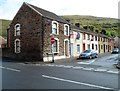
Brook Street, Taibach, Port Talbot
A long row of houses on the NE side of the street, viewed from the Alma Terrace end.
Image: © Jaggery
Taken: 19 Apr 2012
0.05 miles
2
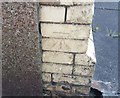
Ordnance Survey Cut Mark
This OS cut mark can be found on No42 Park Street. It marks a point 13.609m above mean sea level.
Image: © Adrian Dust
Taken: 6 May 2020
0.06 miles
3

Ordnance Survey Cut Mark
This OS cut mark can be found on ABC Tyres at the rear of the Rugby Club. It marks a point 10.860m above mean sea level.
Image: © Adrian Dust
Taken: 6 May 2020
0.09 miles
6
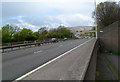
M4 motorway viewed from Inkerman Row, Taibach, Port Talbot
The motorway here is between junction 39 and junction 40 (ahead).
Image: © Jaggery
Taken: 19 Apr 2012
0.09 miles
7
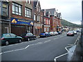
A48 in Taibach looking east
Street scene looking towards traffic lights where left turn leads to Goytre. V good pies across the road.
Image: © Colin Pyle
Taken: 1 Sep 2009
0.10 miles

9
Alma Terrace, Taibach, Port Talbot
Houses on the NE side of the street, viewed from opposite Scutari Row.
Image: © Jaggery
Taken: 19 Apr 2012
0.10 miles
10

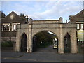
Talbot Memorial Park, Port Talbot
A view to the NE from near the Talbot Road entrance gateway. http://www.geograph.org.uk/photo/2908523
Ahead are the War Memorial http://www.geograph.org.uk/photo/2908539 and a bandstand. http://www.geograph.org.uk/photo/2908545.
Image: © Jaggery
Taken: 19 Apr 2012
0.11 miles