IMAGES TAKEN NEAR TO
PORT TALBOT, SA13 1PT
Introduction
This page details the photographs taken nearby to SA13 1PT by members of the Geograph project.
The Geograph project started in 2005 with the aim of publishing, organising and preserving representative images for every square kilometre of Great Britain, Ireland and the Isle of Man.

There are currently over 7.5m images from over14,400 individuals and you can help contribute to the project by visiting https://www.geograph.org.uk
Image Map (Loading...)


Getting Data...Please wait
Leaflet Map data © OpenStreetMap
Images are licensed for reuse under creativecommons.org/licenses/by-sa/2.0
Notes
- Clicking on the map will re-center to the selected point.
- The higher the marker number, the further away the image location is from the centre of the postcode.
Image Listing (85 Images Found)
Images are licensed for reuse under creativecommons.org/licenses/by-sa/2.0
Image
Details
Distance
1

Capel Dyffryn, Port Talbot
This derelict Welsh Calvinistic Methodist chapel is just in SS77 88 on the 1:25000 OS map, though marked in SS77 89 on the 1:50000 map.
Image: © John Lord
Taken: 17 Oct 2009
0.02 miles
2

Grade II (star) listed War Memorial, Port Talbot
Located inside Talbot Memorial Park, 55 metres ENE of the entrance gateway. http://www.geograph.org.uk/photo/2908523 The memorial is a bronze statue of the Angel of Victory standing on a granite plinth with bronze panels on the sides. The angel holds a laurel wreath in one hand and a small winged Victory (a representation of the Roman goddess of victory) in the other. Grade II (star) Listed in 2000.
Image: © Jaggery
Taken: 19 Apr 2012
0.03 miles
3
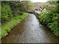
Ffrwd Wyllt flows towards the A48, Taibach, Port Talbot
A tributary of the River Afan, Ffrwd Wyllt is Welsh for wild stream, but here it looks wide enough to be a river. It flows under the A48 at the point where Talbot Road to NW becomes Commercial Road to the SE in the Taibach district of Port Talbot.
Image: © Jaggery
Taken: 19 Apr 2012
0.03 miles
4
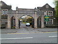
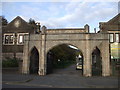
Grade II listed Gateway to Talbot Memorial Park, Port Talbot
Viewed across Talbot Road (the A48). The gateway, between two lodges, is at the SW entrance to Talbot Memorial Park. The year 1925 is inscribed in its stonework. The park contains the town's War Memorial. http://www.geograph.org.uk/photo/2908539
The gateway was Grade II listed in April 2000.
Image: © Jaggery
Taken: 19 Apr 2012
0.04 miles
5
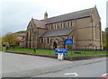
Grade II* listed parish church of St Theodore, Port Talbot
Located at the southern edge of Talbot Park, the Church in Wales church was consecrated on August 5th 1897. It became the parish church of Port Talbot on June 15th 1901. Grade II* listed in February 1975. The church is dedicated to St. Theodore of Tarsus, a Greek monk who was the eighth Archbishop of Canterbury (668-690).
Image: © Jaggery
Taken: 19 Apr 2012
0.04 miles

9

Ordnance Survey Flush Bracket (G3806)
This OS Flush Bracket can be found on the SW face of St Theodore's Church. It marks a point 11.070m above mean sea level.
Image: © Adrian Dust
Taken: 28 Jun 2016
0.06 miles
10
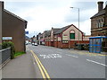
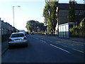
NW boundary of Taibach, Port Talbot
The A48 crosses a bridge over Ffrwd Wyllt http://www.geograph.org.uk/photo/2915659 and enters the Taibach district of Port Talbot.
The A48 is named Talbot Road behind the camera and Commercial Road, Taibach ahead.
On the right is a Filco supermarket. Filco, established in 1946, is a family-run business with several stores in South Wales.
Image: © Jaggery
Taken: 19 Apr 2012
0.06 miles