IMAGES TAKEN NEAR TO
Cound Terrace, PORT TALBOT, SA13 1PP
Introduction
This page details the photographs taken nearby to Cound Terrace, SA13 1PP by members of the Geograph project.
The Geograph project started in 2005 with the aim of publishing, organising and preserving representative images for every square kilometre of Great Britain, Ireland and the Isle of Man.

There are currently over 7.5m images from over14,400 individuals and you can help contribute to the project by visiting https://www.geograph.org.uk
Image Map (Loading...)


Getting Data...Please wait
Leaflet Map data © OpenStreetMap
Images are licensed for reuse under creativecommons.org/licenses/by-sa/2.0
Notes
- Clicking on the map will re-center to the selected point.
- The higher the marker number, the further away the image location is from the centre of the postcode.
Image Listing (80 Images Found)
Images are licensed for reuse under creativecommons.org/licenses/by-sa/2.0
Image
Details
Distance
1
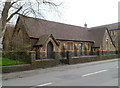
St Theodore's parish hall, Port Talbot
Located on the west side of the church. http://www.geograph.org.uk/photo/2907205
Image: © Jaggery
Taken: 19 Apr 2012
0.02 miles
2

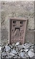
Ordnance Survey Cut Mark
This OS cut mark can be found on No28 Maes-y-Cwrt Terrace. It marks a point 10.692m above mean sea level.
Image: © Adrian Dust
Taken: 6 May 2020
0.03 miles
3
West side of Wyndham Street, Port Talbot
A row of six houses numbered 2 to 12 (even numbers only). At the far end of the street are railings at the edge of railway lines. http://www.geograph.org.uk/photo/2908446 to the opposite side of the street.
Image: © Jaggery
Taken: 19 Apr 2012
0.06 miles
4
East side of Wyndham Street, Port Talbot
A row of six houses numbered 1 to 11 (odd numbers only). At the far end of the street are railings at the edge of railway lines. http://www.geograph.org.uk/photo/2908448 to the opposite side of the street.
Image: © Jaggery
Taken: 19 Apr 2012
0.06 miles
5
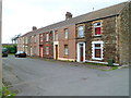
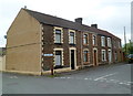
West side of Cound Terrace, Port Talbot
The fence at the end of the street is alongside railway lines.
There are three houses on this side of the street and four on the opposite side.http://www.geograph.org.uk/photo/2907047
Image: © Jaggery
Taken: 19 Apr 2012
0.06 miles
6
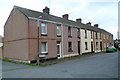
East side of Cound Terrace, Port Talbot
Houses on the east side of a short (25 metres) row of houses located between Talbot Road and railway lines. The car at the right edge of the view is parked next to a fence at the perimeter of the railway.
There are four houses on this side of the street and three on the opposite side.
http://www.geograph.org.uk/photo/2908410
Image: © Jaggery
Taken: 19 Apr 2012
0.06 miles
7
Ordnance Survey Flush Bracket (G3806)
This OS Flush Bracket can be found on the SW face of St Theodore's Church. It marks a point 11.070m above mean sea level.
Image: © Adrian Dust
Taken: 28 Jun 2016
0.07 miles

9
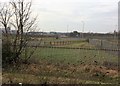
View from a Cardiff-Swansea train - Harbour Way
The bridge is where Harbour Way crosses Ffrwd Wyllt.
Image: © Nigel Thompson
Taken: 27 Jan 2017
0.07 miles
10
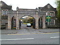
Grade II listed Gateway to Talbot Memorial Park, Port Talbot
Viewed across Talbot Road (the A48). The gateway, between two lodges, is at the SW entrance to Talbot Memorial Park. The year 1925 is inscribed in its stonework. The park contains the town's War Memorial. http://www.geograph.org.uk/photo/2908539
The gateway was Grade II listed in April 2000.
Image: © Jaggery
Taken: 19 Apr 2012
0.07 miles