IMAGES TAKEN NEAR TO
PORT TALBOT, SA13 1PJ
Introduction
This page details the photographs taken nearby to SA13 1PJ by members of the Geograph project.
The Geograph project started in 2005 with the aim of publishing, organising and preserving representative images for every square kilometre of Great Britain, Ireland and the Isle of Man.

There are currently over 7.5m images from over14,400 individuals and you can help contribute to the project by visiting https://www.geograph.org.uk
Image Map (Loading...)


Getting Data...Please wait
Leaflet Map data © OpenStreetMap
Images are licensed for reuse under creativecommons.org/licenses/by-sa/2.0
Notes
- Clicking on the map will re-center to the selected point.
- The higher the marker number, the further away the image location is from the centre of the postcode.
Image Listing (97 Images Found)
Images are licensed for reuse under creativecommons.org/licenses/by-sa/2.0
Image
Details
Distance
1
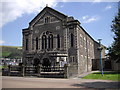
Princess Royal Theatre
798 seat theatre in the centre of Port Talbot
Image: © Alan Roberts
Taken: 10 Oct 2004
0.01 miles
3
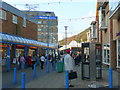
High Street, Port Talbot
There are at least 20 people going about their business in this shot.
Image: © Jonathan Billinger
Taken: 11 Nov 2008
0.05 miles
4
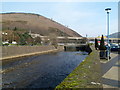
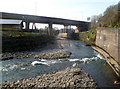
River bridge and river viaduct, Port Talbot
Looking upstream along the River Afan from the edge of a Tesco superstore. http://www.geograph.org.uk/photo/2851410
The bridge carries the eastern end of Heilbronn Way over the river.
Behind the bridge, a viaduct carries the M4 motorway over the river.
Image: © Jaggery
Taken: 2 Mar 2012
0.05 miles
5
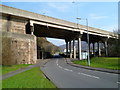
M4 motorway crosses over Cwmavon Road, Port Talbot
The road to Cwmavon (B4286) passes under the M4.
Image: © Jaggery
Taken: 2 Mar 2012
0.05 miles
6
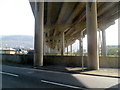
Under the M4 viaduct, Port Talbot
Looking across Cwmavon Road (B4286).
Image: © Jaggery
Taken: 2 Mar 2012
0.05 miles
7
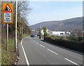
Potential for falling rocks for one mile ahead, Cwmavon Road, Port Talbot
The road ahead is through the steep-sided valley of the River Afan.
Image: © Jaggery
Taken: 2 Mar 2012
0.05 miles
8
River Afan flows under the M4, Port Talbot
Viewed from a point between Velindre Bridge http://www.geograph.org.uk/photo/2851830 and Cwmavon Road (B4286).
Image: © Jaggery
Taken: 2 Mar 2012
0.05 miles
9

The Princess Royal Theatre, Port Talbot
The theatre occupies the NE section of the Civic Centre building. http://www.geograph.org.uk/photo/2851587
Image: © Jaggery
Taken: 2 Mar 2012
0.05 miles
10
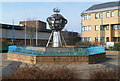
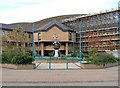
Astrolabe fountain outside Port Talbot Civic Centre
Located in front of the Civic Centre. http://www.geograph.org.uk/photo/2851587
A plaque on the base of the fountain states that the design is based on an astrolabe, the ancient astronomical instrument, and represents the world. It is constructed of Welsh steel and coal products which have made the name of Port Talbot famous all over the world. The model ship symbolizes the port activities. The orbiting satellites suggest that the borough of Port Talbot is forward-looking and ready to accept new advanced developments.
Image: © Jaggery
Taken: 2 Mar 2012
0.05 miles