IMAGES TAKEN NEAR TO
Commercial Road, PORT TALBOT, SA13 1LR
Introduction
This page details the photographs taken nearby to Commercial Road, SA13 1LR by members of the Geograph project.
The Geograph project started in 2005 with the aim of publishing, organising and preserving representative images for every square kilometre of Great Britain, Ireland and the Isle of Man.

There are currently over 7.5m images from over14,400 individuals and you can help contribute to the project by visiting https://www.geograph.org.uk
Image Map (Loading...)


Getting Data...Please wait
Leaflet Map data © OpenStreetMap
Images are licensed for reuse under creativecommons.org/licenses/by-sa/2.0
Notes
- Clicking on the map will re-center to the selected point.
- The higher the marker number, the further away the image location is from the centre of the postcode.
Image Listing (86 Images Found)
Images are licensed for reuse under creativecommons.org/licenses/by-sa/2.0
Image
Details
Distance
1
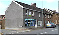
New Look Home Improvements, Taibach, Port Talbot
Shop on the corner of Commercial Road and Woodfield Street.
Image: © Jaggery
Taken: 19 Apr 2012
0.02 miles
2
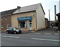
Taibach Pharmacy, Port Talbot
Located at 76 Commercial Road, Taibach, viewed from the Incline Row junction.
Image: © Jaggery
Taken: 19 Apr 2012
0.02 miles
3
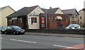
The Old Surgery, Taibach, Port Talbot
Commercial Road pub, located opposite the Incline Row junction.
Image: © Jaggery
Taken: 19 Apr 2012
0.02 miles
4
Prominent advertising for a nearby shop, Taibach, Port Talbot
The board on the side of a row of houses adjacent to the Somerset Arms http://www.geograph.org.uk/photo/2939374 is for a local shop. http://www.geograph.org.uk/photo/2939000
Image: © Jaggery
Taken: 19 Apr 2012
0.02 miles
5

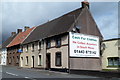
The Somerset Arms, Taibach, Port Talbot
Commercial Road (A48) pub, often referred to locally as The Sker.
Image: © Jaggery
Taken: 19 Apr 2012
0.02 miles
6
Woodfield Street, Taibach, Port Talbot
Viewed from the railway end, looking towards Commercial Road (the A48).
Image: © Jaggery
Taken: 19 Apr 2012
0.02 miles
7
St Albans Terrace, Taibach, Port Talbot
Viewed from the railway end, looking towards Commercial Road (the A48).
Image: © Jaggery
Taken: 19 Apr 2012
0.02 miles
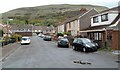
8
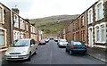
Penrhyn Street, Taibach, Port Talbot
Viewed from the railway end, looking towards Commercial Road (the A48).
Image: © Jaggery
Taken: 19 Apr 2012
0.06 miles
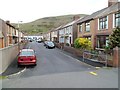
9

SE boundary of Taibach, Port Talbot
Margam Road, Margam (the A48) becomes Commercial Road, Taibach ahead.
Viewed from the corner of Constant Road.
Image: © Jaggery
Taken: 19 Apr 2012
0.06 miles
10

Bricked-up former garage, Penrhyn Street, Taibach, Port Talbot
The derelict, 50' (16m) long building is on the west side of the street.
Image: © Jaggery
Taken: 19 Apr 2012
0.06 miles