IMAGES TAKEN NEAR TO
Abbey Road, PORT TALBOT, SA13 1HB
Introduction
This page details the photographs taken nearby to Abbey Road, SA13 1HB by members of the Geograph project.
The Geograph project started in 2005 with the aim of publishing, organising and preserving representative images for every square kilometre of Great Britain, Ireland and the Isle of Man.

There are currently over 7.5m images from over14,400 individuals and you can help contribute to the project by visiting https://www.geograph.org.uk
Image Map (Loading...)


Getting Data...Please wait
Leaflet Map data © OpenStreetMap
Images are licensed for reuse under creativecommons.org/licenses/by-sa/2.0
Notes
- Clicking on the map will re-center to the selected point.
- The higher the marker number, the further away the image location is from the centre of the postcode.
Image Listing (52 Images Found)
Images are licensed for reuse under creativecommons.org/licenses/by-sa/2.0
Image
Details
Distance
1
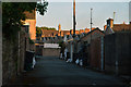
Port Talbot : Alleyway
An alley between Cambrian Place and Gower Street.
Image: © Lewis Clarke
Taken: 23 Jul 2017
0.06 miles
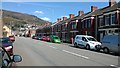
2

Port Talbot : Cambrian Place
Cambrian Place with a for sale sign outside one of the houses.
Image: © Lewis Clarke
Taken: 23 Jul 2017
0.06 miles
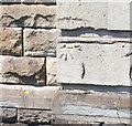
3
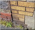
Ordnance Survey Cut Mark
This OS cut mark can be found on No22 George Street. It marks a point 13.707m above mean sea level.
Image: © Adrian Dust
Taken: 6 May 2020
0.08 miles
4
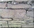
Ordnance Survey Cut Mark
This OS cut mark can be found on the wall SW side of the lane. It marks a point 12.527m above mean sea level.
Image: © Adrian Dust
Taken: 21 Feb 2021
0.08 miles
5
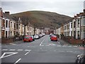
Port Talbot : George Street
George Street in Port Talbot as seen from the junction with York Place and Talcennau Road.
Image: © Lewis Clarke
Taken: 2 Mar 2014
0.10 miles
7

Ordnance Survey Cut Mark
This OS cut mark can be found on No64 Talbot Road. It marks a point 9.507m above mean sea level.
Image: © Adrian Dust
Taken: 6 May 2020
0.11 miles
8
Ordnance Survey Cut Mark
This OS cut mark can be found on the SE face of Dyffryn Lower School. It marks a point 13.164m above mean sea level.
Image: © Adrian Dust
Taken: 6 May 2020
0.11 miles
9
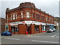
J.R. Motor Spares, Port Talbot
Business on the corner of Talbot Road and Talcennau Road.
Image: © Jaggery
Taken: 19 Apr 2012
0.12 miles
10

Ordnance Survey Cut Mark
This OS cut mark can be found on No28 Maes-y-Cwrt Terrace. It marks a point 10.692m above mean sea level.
Image: © Adrian Dust
Taken: 6 May 2020
0.13 miles