IMAGES TAKEN NEAR TO
Millbrook Estate, SWANSEA, SA1 2NU
Introduction
This page details the photographs taken nearby to Millbrook Estate, SA1 2NU by members of the Geograph project.
The Geograph project started in 2005 with the aim of publishing, organising and preserving representative images for every square kilometre of Great Britain, Ireland and the Isle of Man.

There are currently over 7.5m images from over14,400 individuals and you can help contribute to the project by visiting https://www.geograph.org.uk
Image Map (Loading...)


Getting Data...Please wait
Leaflet Map data © OpenStreetMap
Images are licensed for reuse under creativecommons.org/licenses/by-sa/2.0
Notes
- Clicking on the map will re-center to the selected point.
- The higher the marker number, the further away the image location is from the centre of the postcode.
Image Listing (112 Images Found)
Images are licensed for reuse under creativecommons.org/licenses/by-sa/2.0
Image
Details
Distance
1
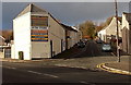
Millbrook Street, Landore, Swansea
Viewed from near the corner of Cwm Level Road and Landeg Street.
Image: © Jaggery
Taken: 6 Dec 2013
0.06 miles
2
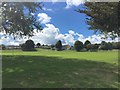
Playing fields
Playing fields at Landore.
Image: © Alan Hughes
Taken: 10 Aug 2018
0.06 miles
3
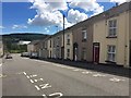
Terraced housing
Terraced houses in Plasmarl, Landore.
Image: © Alan Hughes
Taken: 10 Aug 2018
0.06 miles
4
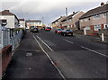
Northern side of Byng Street, Landore, Swansea
Looking north along Byng Street from Siloh Road towards Pwll Street.
Image: © Jaggery
Taken: 6 Dec 2013
0.09 miles
5
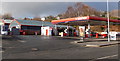
Murco filling station, Landore, Swansea
Viewed across Neath Road. There is a Costcutter shop behind the filling station.
Image: © Jaggery
Taken: 6 Dec 2013
0.10 miles
6
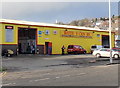
Battery Centre, Landore, Swansea
Viewed across Neath Road.
Image: © Jaggery
Taken: 6 Dec 2013
0.10 miles
7
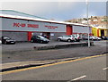
Pic-Up Spares, Landore, Swansea
New and used car spares retailers, Neath Road.
Image: © Jaggery
Taken: 6 Dec 2013
0.10 miles
8
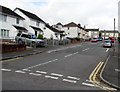
North along Byng Street, Swansea
From Siloh Road, Byng Street ascends towards Pwll Street.
Image: © Jaggery
Taken: 20 Oct 2018
0.10 miles
9
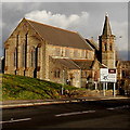
St Paul's Parish Church, Swansea
Viewed across Cwm Level Road. The church was built in 1903, Grade II listed in 1987. At the early December 2013 date of this view, there was no name sign here and the church was fenced off...
Image: © Jaggery
Taken: 6 Dec 2013
0.11 miles
10
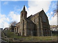
Fenced-off former church on a Plasmarl corner, Swansea
The building on the corner of Cwm Level Road and Neath Road was erected in the early 20th century as St Paul's Parish Church. The building was Grade II listed in 1987. In November 2018 the building is derelict and fenced-off. Out of shot, a warning notice on a fence shows This building is closed - No public access permitted.
Image: © Jaggery
Taken: 12 Nov 2018
0.11 miles