IMAGES TAKEN NEAR TO
Pontrhydyfen, PORT TALBOT, SA12 9SN
Introduction
This page details the photographs taken nearby to SA12 9SN by members of the Geograph project.
The Geograph project started in 2005 with the aim of publishing, organising and preserving representative images for every square kilometre of Great Britain, Ireland and the Isle of Man.

There are currently over 7.5m images from over14,400 individuals and you can help contribute to the project by visiting https://www.geograph.org.uk
Image Map
Images are licensed for reuse under creativecommons.org/licenses/by-sa/2.0
Notes
- Clicking on the map will re-center to the selected point.
- The higher the marker number, the further away the image location is from the centre of the postcode.
Image Listing (7 Images Found)
Images are licensed for reuse under creativecommons.org/licenses/by-sa/2.0
Image
Details
Distance


3
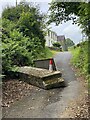
Concrete barrier
Road closure near Pen y Star Farm. The bridge across Afon Pelenna had become too weak to take traffic.
Image: © Alan Hughes
Taken: 7 Jun 2024
0.16 miles
4
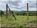
Another public footpath blocked by barbed wire
Image: © Alan Hughes
Taken: 7 Jun 2024
0.18 miles
5
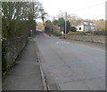
Road from Efail Fach to Neath
The B4287 climbs NW away from the small village of Efail Fach.
The SE suburbs of Neath are about 2 km ahead.
Image: © Jaggery
Taken: 2 Mar 2012
0.20 miles
6
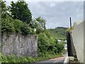
Demolished railway bridge
This bridge used to carry the line which transported coal from above Afon Pelenna across the Pontrhydyfen viaduct and down the Afan valley to Port Talbot.
Image: © Alan Hughes
Taken: 7 Jun 2024
0.22 miles
7
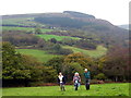
Uwchben Efail Fach / Above Efail Fach
Cerddwyr yn dilyn llwybr cyhoeddus o Efail Fach lan tuag at Ffarm Hawdref Ganol.
Walkers following a public footpath uphill from Efail Fach (trans. little smithy) to Hawdref Ganol Farm.
Image: © Alan Richards
Taken: 14 Oct 2007
0.23 miles