IMAGES TAKEN NEAR TO
Oakwood Avenue, PORT TALBOT, SA12 9SF
Introduction
This page details the photographs taken nearby to Oakwood Avenue, SA12 9SF by members of the Geograph project.
The Geograph project started in 2005 with the aim of publishing, organising and preserving representative images for every square kilometre of Great Britain, Ireland and the Isle of Man.

There are currently over 7.5m images from over14,400 individuals and you can help contribute to the project by visiting https://www.geograph.org.uk
Image Map (Loading...)


Getting Data...Please wait
Leaflet Map data © OpenStreetMap
Images are licensed for reuse under creativecommons.org/licenses/by-sa/2.0
Notes
- Clicking on the map will re-center to the selected point.
- The higher the marker number, the further away the image location is from the centre of the postcode.
Image Listing (83 Images Found)
Images are licensed for reuse under creativecommons.org/licenses/by-sa/2.0
Image
Details
Distance
1
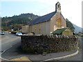
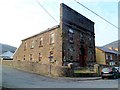
Former St Johns Church, Pontrhydyfen
The former Oakwood Avenue church has been converted to residential use.
Image: © Jaggery
Taken: 2 Mar 2012
0.05 miles
2
Formerly St John’s Church
Converted church in Pontrhydyfen.
Compare Image]
Image: © Alan Hughes
Taken: 7 Jun 2024
0.05 miles
3
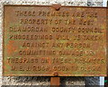
West Glamorgan County Council notice in Pontrhydyfen
Located on the wall of this http://www.geograph.org.uk/photo/3794827 building.
West Glamorgan was created on April 1st 1974 under the terms of the Local Government Act 1972. Following the Local Government (Wales) Act 1994, West Glamorgan County Council ceased to exist on April 1st 1996. It was replaced by two unitary authorities, Swansea and Neath & Port Talbot.
Image: © Jaggery
Taken: 2 Mar 2012
0.06 miles
4
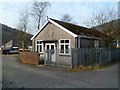
Former West Glamorgan County Council building in Pontrhydyfen
The Oakwood Avenue building in an enclosure has this http://www.geograph.org.uk/photo/3794834 rusting notice on the wall.
West Glamorgan was created on April 1st 1974 under the terms of the Local Government Act 1972. Following the Local Government (Wales) Act 1994, West Glamorgan County Council ceased to exist on April 1st 1996. It was replaced by two unitary authorities, Swansea and Neath & Port Talbot.
Image: © Jaggery
Taken: 2 Mar 2012
0.06 miles
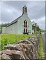
6
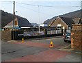
Former Bethel chapel, Pontrhydyfen
Viewed across Oakwood Avenue. At the March 2012 date of this view the former Baptist chapel was disused. It was the 1903 rebuild of the 1850 original. Richard Burton's memorial service was held here after his death in 1984. The world-famous actor was born in Pontrhydyfen in 1925.
Image: © Jaggery
Taken: 2 Mar 2012
0.07 miles
7
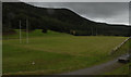
Pontrhydyfen Primary School
Viewed across School Street from the corner of Oakwood Avenue.
Image: © Jaggery
Taken: 2 Mar 2012
0.09 miles
8
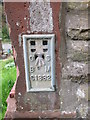
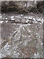
Ordnance Survey Flush Bracket (S1332)
This OS Flush Bracket can be found on the NE angle of the Baptist Chapel. It marks a point 84.289m above mean sea level.
Image: © Adrian Dust
Taken: 14 Aug 2014
0.09 miles
9
Ordnance Survey Cut Mark
This OS cut mark can be found on the corner wall post of the Baptist Chapel. It marks a point 82.485m above mean sea level.
Image: © Adrian Dust
Taken: 14 Aug 2014
0.10 miles
10
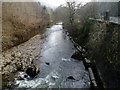
Afon Afan, Pontrhydyfen
The river flows away from this http://www.geograph.org.uk/photo/3794567 footbridge, towards Cwmavon.
Image: © Jaggery
Taken: 2 Mar 2012
0.10 miles