IMAGES TAKEN NEAR TO
Penllyn, PORT TALBOT, SA12 9NL
Introduction
This page details the photographs taken nearby to Penllyn, SA12 9NL by members of the Geograph project.
The Geograph project started in 2005 with the aim of publishing, organising and preserving representative images for every square kilometre of Great Britain, Ireland and the Isle of Man.

There are currently over 7.5m images from over14,400 individuals and you can help contribute to the project by visiting https://www.geograph.org.uk
Image Map
Images are licensed for reuse under creativecommons.org/licenses/by-sa/2.0
Notes
- Clicking on the map will re-center to the selected point.
- The higher the marker number, the further away the image location is from the centre of the postcode.
Image Listing (39 Images Found)
Images are licensed for reuse under creativecommons.org/licenses/by-sa/2.0
Image
Details
Distance
1
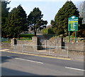
Depot Road entrance to Parc Siencyn Powell, Cwmavon
Sports available in the park are bowls, cricket, football, rugby and tennis. There are a pavilion, a play area and changing facilities. The park used to be known as Parc-y-Llyn.
Image: © Jaggery
Taken: 2 Mar 2012
0.12 miles
2
Cwmavon Evangelical Church, Cwmavon
Located behind a Depot Road bus shelter.
Image: © Jaggery
Taken: 2 Mar 2012
0.13 miles
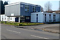
3
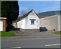
The Old Telephone Exchange, Cwmavon
At the March 2012 date of this view the building housed a band practise room.
Image: © Jaggery
Taken: 2 Mar 2012
0.13 miles
4
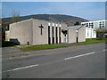
Church with no name, Cwmavon
Viewed across the B4286. There is a large cross on the wall, but no name on this building which is near the library http://www.geograph.org.uk/photo/3709525 on the right.
Image: © Jaggery
Taken: 2 Mar 2012
0.13 miles
5
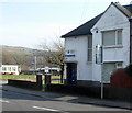
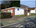
Cwmavon Police Station
Located in Depot Road.
Image: © Jaggery
Taken: 2 Mar 2012
0.14 miles
6
Cwmavon Library
Located in Depot Road, part of Neath Port Talbot County Borough's library service.
Image: © Jaggery
Taken: 2 Mar 2012
0.14 miles
7
Depot Road houses NE of Afon Veterinary Centre, Cwmavon
Afon Veterinary Centre http://www.geograph.org.uk/photo/3709455 is on the left.
Image: © Jaggery
Taken: 2 Mar 2012
0.14 miles
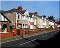
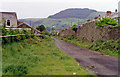
8
Eastern side of Penllyn, Cwmavon
Penllyn is a large area of houses and flats on the north side of the B4286.
Image: © Jaggery
Taken: 2 Mar 2012
0.15 miles
9
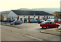
The Co-operative Food store in Cwmavon
Viewed across Heol Jiwbili.
Image: © Jaggery
Taken: 2 Mar 2012
0.15 miles
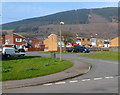
10
Site of Cwmavon station, 1990
View SW down the Cwm Avon valley, towards Aberavon, Neath and Swansea: ex-GW, Rhondda & Swansea Bay line, Treherbert - Aberavon (Seaside)/port Talbot - Court Sart/Neath - Swansea East Dock line, closed 3/12/62 to passengers, 2/11/64 to goods, although the line west of Aberavon remained for freight for about 10 more years - see Image The mountain ahead is Mynydd Emroch (735 ft.)
Image: © Ben Brooksbank
Taken: 19 May 1990
0.15 miles