IMAGES TAKEN NEAR TO
Bwlch Road, PORT TALBOT, SA12 8YG
Introduction
This page details the photographs taken nearby to Bwlch Road, SA12 8YG by members of the Geograph project.
The Geograph project started in 2005 with the aim of publishing, organising and preserving representative images for every square kilometre of Great Britain, Ireland and the Isle of Man.

There are currently over 7.5m images from over14,400 individuals and you can help contribute to the project by visiting https://www.geograph.org.uk
Image Map
Images are licensed for reuse under creativecommons.org/licenses/by-sa/2.0
Notes
- Clicking on the map will re-center to the selected point.
- The higher the marker number, the further away the image location is from the centre of the postcode.
Image Listing (16 Images Found)
Images are licensed for reuse under creativecommons.org/licenses/by-sa/2.0
Image
Details
Distance
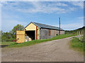
1
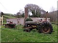
Tractor on Blaen Baglan Farm
This Fordson Major is set up to power a sawbench with the pulley and flat belt system which was more or less standard on these old tractors. This could be used to power various machinery previously driven by steam engines e.g. a threshing machine. It didn't look like it had been functional at any recent time as the blade and tractor itself was showing signs of decay.
The building behind the tractor showed signs of extensive fire - presumably the wooden roof has long since gone. I'm not sure if this was once part of the farm or part of a nearby coal mine.
Image: © Hywel Williams
Taken: 8 Nov 2011
0.02 miles
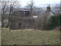
2

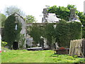
Blaen Baglan Farm
This is the derelict remains of Blaen Baglan Farm. The surrounding land is however still very much in use by a local farmer who uses the outhouses and other farm buildings for everyday use.
Image: © Hywel Williams
Taken: 8 Nov 2011
0.02 miles
5

Ordnance Survey Cut Mark
This OS cut mark can be found on the roadside barn at Blaen Baglan Farm. It marks a point 117.488m above mean sea level.
Image: © Adrian Dust
Taken: 26 May 2018
0.04 miles
7
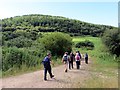
Tuag at Fynydd Dinas / Towards Mynydd Dinas
Cerddwyr yn dilyn llwybr i gyfeiriad Mynydd Dinas yn y pellter.
Walkers following a path in the direction of Mynydd Dinas (trans. hillfort mountain) in the distance.
Image: © Alan Richards
Taken: 6 Jul 2014
0.14 miles
8
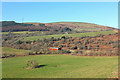
View near Blaen-Baglan
View from a path overlooking Blaen-Baglan.
Image: © Wayland Smith
Taken: 21 Mar 2015
0.14 miles