IMAGES TAKEN NEAR TO
Cwmavon Road, PORT TALBOT, SA12 8RB
Introduction
This page details the photographs taken nearby to Cwmavon Road, SA12 8RB by members of the Geograph project.
The Geograph project started in 2005 with the aim of publishing, organising and preserving representative images for every square kilometre of Great Britain, Ireland and the Isle of Man.

There are currently over 7.5m images from over14,400 individuals and you can help contribute to the project by visiting https://www.geograph.org.uk
Image Map (Loading...)


Getting Data...Please wait
Leaflet Map data © OpenStreetMap
Images are licensed for reuse under creativecommons.org/licenses/by-sa/2.0
Notes
- Clicking on the map will re-center to the selected point.
- The higher the marker number, the further away the image location is from the centre of the postcode.
Image Listing (15 Images Found)
Images are licensed for reuse under creativecommons.org/licenses/by-sa/2.0
Image
Details
Distance
1
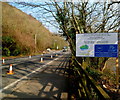
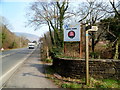
Sustrans board alongside the B4286 near Cwmavon
The board shows
Neath Port Talbot County Borough Council
Valley Cycle Network
Route 887, Aberavon to Afan Forest Park.
In the blue rectangle are the emblems of the Welsh Government and the European Regional Development Fund and the motto Europe & Wales : Investing in your Future.
Image: © Jaggery
Taken: 2 Mar 2012
0.03 miles
2
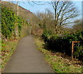
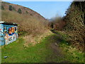
Riverside path to Cwmavon Road south of Cwmavon
The path connects this http://www.geograph.org.uk/photo/3701375 footbridge with Cwmavon Road. Ahead, steps ascend to Cwmavon Road.
Image: © Jaggery
Taken: 2 Mar 2012
0.04 miles
3
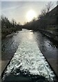
Afon Afan flows towards a footbridge south of Cwmavon
Viewed from this http://www.geograph.org.uk/photo/3690904 footbridge.
Image: © Jaggery
Taken: 2 Mar 2012
0.04 miles
4
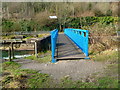
Across a river footbridge south of Cwmavon
The bridge spans the Afon Afan. http://www.geograph.org.uk/photo/3690904
Image: © Jaggery
Taken: 2 Mar 2012
0.06 miles
5
Track through the Afan Valley
Looking north along a track on the east bank of the Afon Afan, viewed from near this http://www.geograph.org.uk/photo/3690904 footbridge.
Image: © Jaggery
Taken: 2 Mar 2012
0.06 miles
7
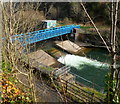
Blue footbridge over the Afon Afan south of Cwmavon
Viewed from the B4286 Cwmavon Road.
Image: © Jaggery
Taken: 2 Mar 2012
0.07 miles
8
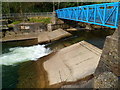
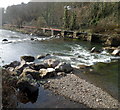
White water in the Afon Afan south of Cwmavon
The river rushes underneath a footbridge which leads to the B4286 Cwmavon Road.
A notice on the wall on the far bank shows AFAN VALLEY ANGLING CLUB PRIVATE FISHING.
Image: © Jaggery
Taken: 2 Mar 2012
0.07 miles
9
Boulders across the Afon Afan south of Cwmavon
Perhaps the remains of a weir?
Image: © Jaggery
Taken: 2 Mar 2012
0.10 miles
10
Ynys Park board near Cwmavon
The board at the edge of the B4286 Cwmavon Road shows
Ynys Park and Trefelin Boys & Girls Club founded 1984.
Image: © Jaggery
Taken: 2 Mar 2012
0.11 miles