IMAGES TAKEN NEAR TO
Pentyla Baglan Road, PORT TALBOT, SA12 8DX
Introduction
This page details the photographs taken nearby to Pentyla Baglan Road, SA12 8DX by members of the Geograph project.
The Geograph project started in 2005 with the aim of publishing, organising and preserving representative images for every square kilometre of Great Britain, Ireland and the Isle of Man.

There are currently over 7.5m images from over14,400 individuals and you can help contribute to the project by visiting https://www.geograph.org.uk
Image Map
Images are licensed for reuse under creativecommons.org/licenses/by-sa/2.0
Notes
- Clicking on the map will re-center to the selected point.
- The higher the marker number, the further away the image location is from the centre of the postcode.
Image Listing (14 Images Found)
Images are licensed for reuse under creativecommons.org/licenses/by-sa/2.0
Image
Details
Distance
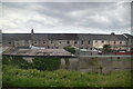
1
Neath Port Talbot : M4 Motorway
The M4 Motorway looking eastbound as it heads through Neath Port Talbot.
Image: © Lewis Clarke
Taken: 11 Apr 2014
0.03 miles
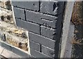
2
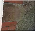
Ordnance Survey Cut Mark
This OS cut mark can be found on No73 Pentyla Baglan Road. It marks a point 27.328m above mean sea level.
Image: © Adrian Dust
Taken: 11 Jun 2020
0.04 miles
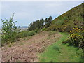
3

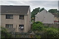
Overlooking the M4
Near the slip road.
Image: © Deborah Tilley
Taken: 17 Jan 2010
0.10 miles
5

Neath Port Talbot : M4 Motorway
The M4 Motorway heading westbound through the M4 Motorway.
Image: © Lewis Clarke
Taken: 10 Apr 2014
0.15 miles
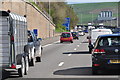
6
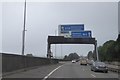
M4 sign gantry ahead of junction 41
The sign in Image but with more traffic
Image: © David Smith
Taken: 1 Jun 2018
0.16 miles
7
Ordnance Survey Cut Mark
This OS cut mark can be found on No42 John Street. It marks a point 5.712m above mean sea level.
Image: © Adrian Dust
Taken: 11 Jun 2020
0.17 miles