IMAGES TAKEN NEAR TO
Pinewood Terrace, PORT TALBOT, SA12 8BH
Introduction
This page details the photographs taken nearby to Pinewood Terrace, SA12 8BH by members of the Geograph project.
The Geograph project started in 2005 with the aim of publishing, organising and preserving representative images for every square kilometre of Great Britain, Ireland and the Isle of Man.

There are currently over 7.5m images from over14,400 individuals and you can help contribute to the project by visiting https://www.geograph.org.uk
Image Map (Loading...)


Getting Data...Please wait
Leaflet Map data © OpenStreetMap
Images are licensed for reuse under creativecommons.org/licenses/by-sa/2.0
Notes
- Clicking on the map will re-center to the selected point.
- The higher the marker number, the further away the image location is from the centre of the postcode.
Image Listing (15 Images Found)
Images are licensed for reuse under creativecommons.org/licenses/by-sa/2.0
Image
Details
Distance
1
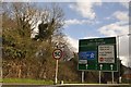
Baglan : A48 Road Sign
A road sign alongside the A48 with directions to Cardiff, and Aberavon.
Image: © Lewis Clarke
Taken: 23 Mar 2014
0.04 miles
2
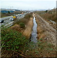
Drainage channel between motorway and railway, Baglan
Viewed from the A4241 Seaview Parade bridge.
The M4 motorway is on the left. The South Wales Main Line http://www.geograph.org.uk/photo/3839396 is beyond the fence on the right.
Image: © Jaggery
Taken: 8 Mar 2012
0.09 miles
3
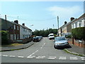
Burrows Road
Close to the centre of the square - Looking West towards the railway and M4.
Image: © Chris Shaw
Taken: 26 Jul 2006
0.10 miles
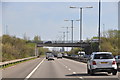
4
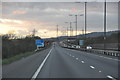
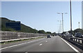
Neath Port Talbot : M4 Motorway
The M4 Motorway heading westbound through Neath Port Talbot.
Image: © Lewis Clarke
Taken: 10 Apr 2014
0.10 miles
5
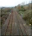
Railway NW of Baglan station
Viewed from Seaway Parade bridge looking along the South Wales Main Line towards Briton Ferry station. Baglan station http://www.geograph.org.uk/photo/2839294 is behind the camera, on the opposite side of the bridge.
The small yellow milepost on the right shows 204 (miles).
Image: © Jaggery
Taken: 8 Mar 2012
0.10 miles
6
M4 motorway NW of Seaway Parade, Baglan
Viewed from the A4241 Seaway Parade bridge looking towards Seaway Parade Industrial Estate.
Image: © Jaggery
Taken: 8 Mar 2012
0.13 miles

8
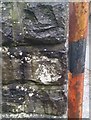
Ordnance Survey Cut Mark
This OS cut mark can be found on the post south side if the road. It marks a point 9.187m above mean sea level.
Image: © Adrian Dust
Taken: 25 May 2018
0.15 miles
9
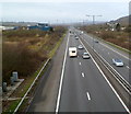
Neath Port Talbot : M4 Motorway
The M4 Motorway looking eastbound as it heads through Neath Port Talbot.
Image: © Lewis Clarke
Taken: 11 Apr 2014
0.15 miles