IMAGES TAKEN NEAR TO
Pentre Afan, PORT TALBOT, SA12 7RN
Introduction
This page details the photographs taken nearby to Pentre Afan, SA12 7RN by members of the Geograph project.
The Geograph project started in 2005 with the aim of publishing, organising and preserving representative images for every square kilometre of Great Britain, Ireland and the Isle of Man.

There are currently over 7.5m images from over14,400 individuals and you can help contribute to the project by visiting https://www.geograph.org.uk
Image Map
Images are licensed for reuse under creativecommons.org/licenses/by-sa/2.0
Notes
- Clicking on the map will re-center to the selected point.
- The higher the marker number, the further away the image location is from the centre of the postcode.
Image Listing (7 Images Found)
Images are licensed for reuse under creativecommons.org/licenses/by-sa/2.0
Image
Details
Distance
1
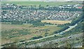
North Aberavon
Housing estate and sports ground - birds eye view from hills to the East.
Image: © Chris Shaw
Taken: Unknown
0.08 miles
2
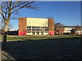
Sandfields Comprehensive School
Sandfields Comprehensive School, Aberavon.
Image: © Alan Hughes
Taken: 1 Dec 2016
0.17 miles
3

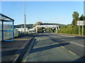
Footbridge over Ffordd Afan Way, Baglan
Image: © David Howard
Taken: 21 Jul 2024
0.17 miles
4
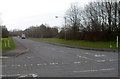
Moor Road, Baglan
Looking SSW from Baglan Way.
Image: © Jaggery
Taken: 8 Mar 2012
0.18 miles
5
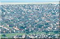
Sandfields
Mainly Residential - from the North East
Image: © Chris Shaw
Taken: Unknown
0.18 miles
7
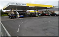
Morrisons filling station, Baglan
In the NW corner of the Morrisons http://www.geograph.org.uk/photo/3833207 site in Baglan Industrial Park. Maximum height under the canopy is shown as 12' 1". The metric equivalent is the very precise 3700mm rather than 3.7 metres.
Image: © Jaggery
Taken: 8 Mar 2012
0.24 miles