IMAGES TAKEN NEAR TO
Chrome Avenue, PORT TALBOT, SA12 7RF
Introduction
This page details the photographs taken nearby to Chrome Avenue, SA12 7RF by members of the Geograph project.
The Geograph project started in 2005 with the aim of publishing, organising and preserving representative images for every square kilometre of Great Britain, Ireland and the Isle of Man.

There are currently over 7.5m images from over14,400 individuals and you can help contribute to the project by visiting https://www.geograph.org.uk
Image Map
Images are licensed for reuse under creativecommons.org/licenses/by-sa/2.0
Notes
- Clicking on the map will re-center to the selected point.
- The higher the marker number, the further away the image location is from the centre of the postcode.
Image Listing (13 Images Found)
Images are licensed for reuse under creativecommons.org/licenses/by-sa/2.0
Image
Details
Distance
1
Ordnance Survey Rivet
This is one of six OS rivets which can be found on the sea wall above Aberavon Sands. It can be found next to a set of beach steps. It marks a point 10.086m above mean sea level.
Image: © Adrian Dust
Taken: 22 Mar 2014
0.15 miles
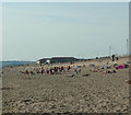
2
Port Talbot : Coastal Scenery
Looking towards the coastline from the Princess Margaret Way.
Image: © Lewis Clarke
Taken: 23 Mar 2014
0.15 miles
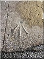
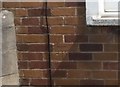
3

Ordnance Survey Cut Mark
This OS cut mark can be found on No171 Western Avenue. It marks a point 11.012m above mean sea level.
Image: © Adrian Dust
Taken: 4 May 2020
0.17 miles
4
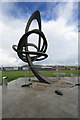
Kite Trail sculpture at Aberavon
Kite Trail sculpture at the seafront at Aberavon by Andrew Rowe.
Wales' largest sculpture, installed in December 2007.
Image: © Darren W Rees
Taken: 12 Aug 2008
0.18 miles
5
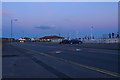
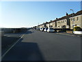
Port Talbot : The Princess Margaret Way
Looking along a road which heads alongside the coastline.
Image: © Lewis Clarke
Taken: 23 Jul 2017
0.18 miles
7
Ordnance Survey Cut Mark
This OS cut mark can be found on No77 Western Avenue. It marks a point 11.729m above mean sea level.
Image: © Adrian Dust
Taken: 4 May 2020
0.20 miles
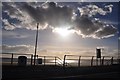
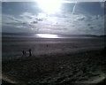
8
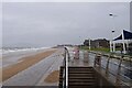
Wind and rain lash Aberavon Beach
A stormy day in Port Talbot
Image: © John Myers
Taken: 29 Sep 2024
0.21 miles