IMAGES TAKEN NEAR TO
Auburn Avenue, PORT TALBOT, SA12 7PU
Introduction
This page details the photographs taken nearby to Auburn Avenue, SA12 7PU by members of the Geograph project.
The Geograph project started in 2005 with the aim of publishing, organising and preserving representative images for every square kilometre of Great Britain, Ireland and the Isle of Man.

There are currently over 7.5m images from over14,400 individuals and you can help contribute to the project by visiting https://www.geograph.org.uk
Image Map
Images are licensed for reuse under creativecommons.org/licenses/by-sa/2.0
Notes
- Clicking on the map will re-center to the selected point.
- The higher the marker number, the further away the image location is from the centre of the postcode.
Image Listing (15 Images Found)
Images are licensed for reuse under creativecommons.org/licenses/by-sa/2.0
Image
Details
Distance
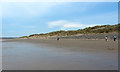
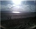
1
Traeth Aberafan / Aberavon Beach
Traeth gorllewinol Aberafan.
Western end of Aberavon Beach.
Image: © Alan Richards
Taken: 6 Jul 2014
0.13 miles
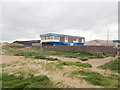
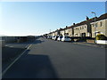
2
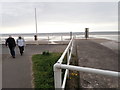
Western end of the Marine Walk, Aberavon
Image: © Eirian Evans
Taken: 6 May 2019
0.13 miles
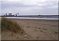
5
Aberavon beach
Looking over the sand dunes at the end of Aberavon beach across Swansea Bay.
Image: © Helen
Taken: 6 Apr 2015
0.15 miles
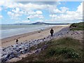
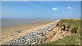
9
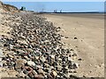
Pebble bank on Aberavon beach
Port Talbot harbour in the distance.
Image: © Alan Hughes
Taken: 7 Jul 2023
0.16 miles