IMAGES TAKEN NEAR TO
St. Asaph Drive, PORT TALBOT, SA12 7LL
Introduction
This page details the photographs taken nearby to St. Asaph Drive, SA12 7LL by members of the Geograph project.
The Geograph project started in 2005 with the aim of publishing, organising and preserving representative images for every square kilometre of Great Britain, Ireland and the Isle of Man.

There are currently over 7.5m images from over14,400 individuals and you can help contribute to the project by visiting https://www.geograph.org.uk
Image Map
Images are licensed for reuse under creativecommons.org/licenses/by-sa/2.0
Notes
- Clicking on the map will re-center to the selected point.
- The higher the marker number, the further away the image location is from the centre of the postcode.
Image Listing (6 Images Found)
Images are licensed for reuse under creativecommons.org/licenses/by-sa/2.0
Image
Details
Distance
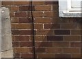
1

Ordnance Survey Cut Mark
This OS cut mark can be found on No171 Western Avenue. It marks a point 11.012m above mean sea level.
Image: © Adrian Dust
Taken: 4 May 2020
0.09 miles
2
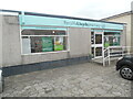
LloydsPharmacy, Sandfields
This pharmacy is located at 187 Western Avenue, SA12 7NE. Its future though is uncertain according to the dark green notice in its front window https://www.geograph.org.uk/photo/7430514 refers.
Image: © David Hillas
Taken: 6 Mar 2023
0.16 miles
3
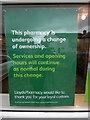
Information Notice at LloydsPharmacy, Sandfields
This notice is on the front window of LloydsPharmacy in Western Avenue. It has the following wording:
This pharmacy is
undergoing a change
of ownership.
Services and opening
hours will continue
as normal during
this change.
LloydsPharmacy would like to
thank you for your loyal custom.
If you have any questions, please see our website
LloydsPharmacy.com
Image: © David Hillas
Taken: 6 Mar 2023
0.16 miles
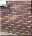
4
Ordnance Survey Cut Mark
This OS cut mark can be found on No77 Western Avenue. It marks a point 11.729m above mean sea level.
Image: © Adrian Dust
Taken: 4 May 2020
0.18 miles
5
Ordnance Survey Cut Mark
This repositioned OS cut mark can be found on No232 Western Avenue. It marked a point 11.259m above mean sea level.
Image: © Adrian Dust
Taken: 4 May 2020
0.22 miles
6
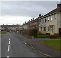
Acacia Close, Port Talbot
Viewed from the Acacia Avenue end.
Image: © Jaggery
Taken: 8 Mar 2012
0.23 miles