IMAGES TAKEN NEAR TO
Rhodes Avenue, PORT TALBOT, SA12 6YU
Introduction
This page details the photographs taken nearby to Rhodes Avenue, SA12 6YU by members of the Geograph project.
The Geograph project started in 2005 with the aim of publishing, organising and preserving representative images for every square kilometre of Great Britain, Ireland and the Isle of Man.

There are currently over 7.5m images from over14,400 individuals and you can help contribute to the project by visiting https://www.geograph.org.uk
Image Map
Images are licensed for reuse under creativecommons.org/licenses/by-sa/2.0
Notes
- Clicking on the map will re-center to the selected point.
- The higher the marker number, the further away the image location is from the centre of the postcode.
Image Listing (13 Images Found)
Images are licensed for reuse under creativecommons.org/licenses/by-sa/2.0
Image
Details
Distance
1
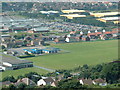
North Aberavon
School, shopping and industrial estate in the northern half of the square - taken from the lower slopes of Mynydd Dinas.
December 2009, a site visitor adds - The school on the left hand side is the Roman Catholic Comprehensive School named St Joseph's; the blue painted buildings belong to St Joseph's Junior School. The building with the car park in front of it is the new General Hospital (Port Talbot General Hospital). The sandy coloured buildings are part of the Baglan Business Park.
Image: © Chris Shaw
Taken: Unknown
0.09 miles
2
Y Rhosyn Cancer Support Day Care Centre, Port Talbot
Image: © Mick Lobb
Taken: 30 Dec 2008
0.15 miles
3
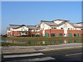
Neath Port Talbot Hospital, Port Talbot
Viewed from Baglan Way.
Image: © Jaggery
Taken: 8 Mar 2012
0.17 miles
4
Neath Port Talbot Hospital
Neath Port Talbot Hospital is a non acute secondary care 270-bed hospital located in Port Talbot
Image: © Alan Hughes
Taken: 27 Dec 2018
0.17 miles
5
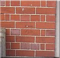
Ordnance Survey Cut Mark
This OS cut mark can be found on the school building to the NW of Lilian Street. It marks a point 7.096m above mean sea level.
Image: © Adrian Dust
Taken: 22 Mar 2014
0.20 miles
6

Neath Port Talbot : M4 Motorway
The M4 Motorway heading westbound through the M4 Motorway.
Image: © Lewis Clarke
Taken: 10 Apr 2014
0.21 miles
7
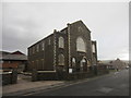
Salem Chapel
There is an OS cut mark on the south angle of the chapel. http://www.geograph.org.uk/photo/3896255
Image: © Adrian Dust
Taken: 22 Mar 2014
0.21 miles
8
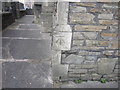
Ordnance Survey Cut Mark
This OS cut mark can be found on the corner of the Salem Chapel on Sandfields Road. It marks a point 6.578m above mean sea level. http://www.geograph.org.uk/photo/3896258
Image: © Adrian Dust
Taken: 22 Mar 2014
0.22 miles

10
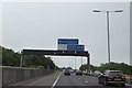
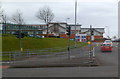
Motorway sign gantry ahead of junction 41 westbound
On the left, the barrier is designed to deflect road noise from the nearby school
Image: © David Smith
Taken: 1 Jun 2018
0.23 miles