IMAGES TAKEN NEAR TO
Alfred Street, PORT TALBOT, SA12 6UL
Introduction
This page details the photographs taken nearby to Alfred Street, SA12 6UL by members of the Geograph project.
The Geograph project started in 2005 with the aim of publishing, organising and preserving representative images for every square kilometre of Great Britain, Ireland and the Isle of Man.

There are currently over 7.5m images from over14,400 individuals and you can help contribute to the project by visiting https://www.geograph.org.uk
Image Map
Images are licensed for reuse under creativecommons.org/licenses/by-sa/2.0
Notes
- Clicking on the map will re-center to the selected point.
- The higher the marker number, the further away the image location is from the centre of the postcode.
Image Listing (34 Images Found)
Images are licensed for reuse under creativecommons.org/licenses/by-sa/2.0
Image
Details
Distance
1
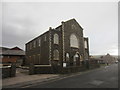
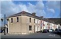
Salem Chapel
There is an OS cut mark on the south angle of the chapel. http://www.geograph.org.uk/photo/3896255
Image: © Adrian Dust
Taken: 22 Mar 2014
0.05 miles
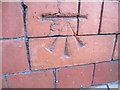
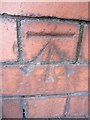
2
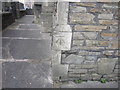
Ordnance Survey Cut Mark
This OS cut mark can be found on the corner of the Salem Chapel on Sandfields Road. It marks a point 6.578m above mean sea level. http://www.geograph.org.uk/photo/3896258
Image: © Adrian Dust
Taken: 22 Mar 2014
0.05 miles
3
Ordnance Survey Cut Mark
This OS cut mark can be found on the front of No43 Angel Street. It marks a point 5.663m above mean sea level.
Image: © Adrian Dust
Taken: 22 Mar 2014
0.08 miles
4
Ordnance Survey Cut Mark
This OS cut mark can be found on the school building to the NW of Lilian Street. It marks a point 7.096m above mean sea level.
Image: © Adrian Dust
Taken: 22 Mar 2014
0.10 miles
5
Beach Street, Port Talbot
Houses on the west side of Beach Street viewed from Ysguthan Road.
Image: © Jaggery
Taken: 8 Mar 2012
0.12 miles
6
Ordnance Survey Cut Mark
This OS cut mark can be found on the school building to the NE of Pendarvis Terrace, opposite No19. It marks a point 7.983m above mean sea level.
Image: © Adrian Dust
Taken: 22 Mar 2014
0.13 miles
7
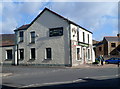
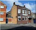
Burgess Green, Port Talbot
Pub on the corner of Ysguthan Road and Bevan Street.
Image: © Jaggery
Taken: 8 Mar 2012
0.14 miles
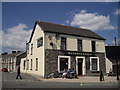
9
Aberavon Liberal Club, Port Talbot
Located in Ysguthan Road opposite Henshaw Street.
Image: © Jaggery
Taken: 8 Mar 2012
0.14 miles
10
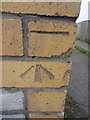
Ordnance Survey Cut Mark
This OS cut mark can be found on the brick pillar at the junction of Pendarvis Terrace & Lilian Street. It marks a point 7.239m above mean sea level.
Image: © Adrian Dust
Taken: 22 Mar 2014
0.14 miles