IMAGES TAKEN NEAR TO
Lingfield Avenue, PORT TALBOT, SA12 6NX
Introduction
This page details the photographs taken nearby to Lingfield Avenue, SA12 6NX by members of the Geograph project.
The Geograph project started in 2005 with the aim of publishing, organising and preserving representative images for every square kilometre of Great Britain, Ireland and the Isle of Man.

There are currently over 7.5m images from over14,400 individuals and you can help contribute to the project by visiting https://www.geograph.org.uk
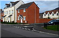
Image Map
Images are licensed for reuse under creativecommons.org/licenses/by-sa/2.0
Notes
- Clicking on the map will re-center to the selected point.
- The higher the marker number, the further away the image location is from the centre of the postcode.
Image Listing (24 Images Found)
Images are licensed for reuse under creativecommons.org/licenses/by-sa/2.0
Image
Details
Distance
1

Ordnance Survey Rivet
This OS rivet can be found on the wall of No25 Lingfield Avenue. It marks a point 8.675m above mean sea level.
Image: © Adrian Dust
Taken: 4 May 2020
0.02 miles
2
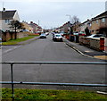
Lingfield Avenue, Aberavon, Port Talbot
Looking SE from railings.
Image: © Jaggery
Taken: 8 Mar 2012
0.03 miles
3
Rembrandt Place, Port Talbot
Located north of Lingfield Avenue and west of the A4241 Afan Way.
Image: © Jaggery
Taken: 8 Mar 2012
0.09 miles
4
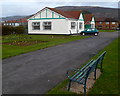
Bench and pavilion in Vivian Park, Port Talbot
On the north side of a bowling green. http://www.geograph.org.uk/photo/3830770
Image: © Jaggery
Taken: 8 Mar 2012
0.09 miles
5
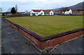
Vivian Park bowling green, Port Talbot
One of two bowling greens side by side. A small part of the second green is in the upper right corner.
Image: © Jaggery
Taken: 8 Mar 2012
0.09 miles
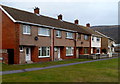
6
21st century houses in Port Talbot
Recently-built houses in Hospital Road.
Image: © Jaggery
Taken: 8 Mar 2012
0.12 miles
7
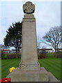
Vivian Park Great War Memorial, Port Talbot
The inscription on the base shows that the memorial was erected
by Robert B. Byass & Company in memory of their employees
who died in the Great War (1914-1918).
The Great War is now generally known as the First World War.
Image: © Jaggery
Taken: 8 Mar 2012
0.13 miles
8
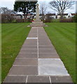
Path to the Great War Memorial in Vivian Park, Port Talbot
http://www.geograph.org.uk/photo/3830828 to a closer view of the Memorial.
Image: © Jaggery
Taken: 8 Mar 2012
0.13 miles
9

Ordnance Survey Rivet
This OS rivet can be found on the wall post SE side of The Poplars. It marks a point 9.662m above mean sea level.
Image: © Adrian Dust
Taken: 4 May 2020
0.13 miles
10
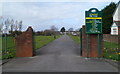
Southern entrance to Vivian Park, Port Talbot
From Moorland Road, opposite the Wheatley Avenue junction.
Image: © Jaggery
Taken: 8 Mar 2012
0.14 miles