IMAGES TAKEN NEAR TO
Ysguthan Road, PORT TALBOT, SA12 6NE
Introduction
This page details the photographs taken nearby to Ysguthan Road, SA12 6NE by members of the Geograph project.
The Geograph project started in 2005 with the aim of publishing, organising and preserving representative images for every square kilometre of Great Britain, Ireland and the Isle of Man.

There are currently over 7.5m images from over14,400 individuals and you can help contribute to the project by visiting https://www.geograph.org.uk
Image Map
Images are licensed for reuse under creativecommons.org/licenses/by-sa/2.0
Notes
- Clicking on the map will re-center to the selected point.
- The higher the marker number, the further away the image location is from the centre of the postcode.
Image Listing (51 Images Found)
Images are licensed for reuse under creativecommons.org/licenses/by-sa/2.0
Image
Details
Distance
1
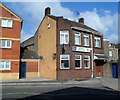
Aberavon Liberal Club, Port Talbot
Located in Ysguthan Road opposite Henshaw Street.
Image: © Jaggery
Taken: 8 Mar 2012
0.01 miles
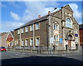
2
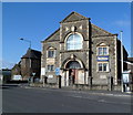
Bethlehem Evangelical Church, Port Talbot
The church is at 30 Ysguthan Road, on the corner of Pendarvis Terrace.
The year 1914 in inscribed on the arch over the doorway.
http://www.geograph.org.uk/photo/3381542 to a corner view
Image: © Jaggery
Taken: 8 Mar 2012
0.02 miles
3
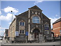
Bethlehem Evangelical Church, Sandfields, Aberavon
Originally a Forward Movement church. The outstanding preacher Martyn Lloyd-Jones, for many years minister at Westminster Chapel in central London, was previously pastor here 1927-1938.
Image: © John Lord
Taken: 14 Jul 2011
0.02 miles
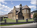
5
Corner view of Bethlehem Evangelical Church, Port Talbot
The church is at 30 Ysguthan Road, on the corner of Pendarvis Terrace.
The year 1914 in inscribed on the arch over the doorway.
http://www.geograph.org.uk/photo/3381470 to another view.
Image: © Jaggery
Taken: 8 Mar 2012
0.02 miles
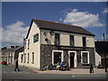
6
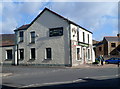
Burgess Green, Port Talbot
Pub on the corner of Ysguthan Road and Bevan Street.
Image: © Jaggery
Taken: 8 Mar 2012
0.02 miles
7
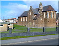
St Paul's church, Port Talbot
Viewed across Victoria Road. The Church in Wales church is on the corner of Pendarvis Terrace.
Image: © Jaggery
Taken: 8 Mar 2012
0.04 miles
9
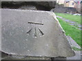
Ordnance Survey Cut Mark
This OS cut mark can be found on the NW side of St Paul's Church. It marks a point 7.983m above mean sea level.
Image: © Adrian Dust
Taken: 22 Mar 2014
0.05 miles
10
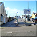
Eastern end of a footbridge across Afan Road, Port Talbot
A view of the footbridge http://www.geograph.org.uk/photo/3381574 from Victoria Road at the corner of Glyn Street.
Image: © Jaggery
Taken: 8 Mar 2012
0.07 miles