IMAGES TAKEN NEAR TO
Wellington Place, PORT TALBOT, SA12 6LN
Introduction
This page details the photographs taken nearby to Wellington Place, SA12 6LN by members of the Geograph project.
The Geograph project started in 2005 with the aim of publishing, organising and preserving representative images for every square kilometre of Great Britain, Ireland and the Isle of Man.

There are currently over 7.5m images from over14,400 individuals and you can help contribute to the project by visiting https://www.geograph.org.uk
Image Map
Images are licensed for reuse under creativecommons.org/licenses/by-sa/2.0
Notes
- Clicking on the map will re-center to the selected point.
- The higher the marker number, the further away the image location is from the centre of the postcode.
Image Listing (58 Images Found)
Images are licensed for reuse under creativecommons.org/licenses/by-sa/2.0
Image
Details
Distance
1
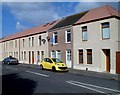
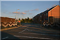
Water Street houses, Port Talbot
Viewed looking towards the Wellington Place junction just out of shot ahead.
Image: © Jaggery
Taken: 8 Mar 2012
0.04 miles
2
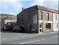
Talbot Glass, Port Talbot
Business at 168 Water Street on the corner of Wellington Place.
Image: © Jaggery
Taken: 8 Mar 2012
0.04 miles
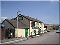
4
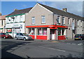
Ladbrokes, Pembroke Terrace, Port Talbot
Viewed from Water Street. The Ladbrokes betting shop is on the corner of Pembroke Terrace and Ysguthan Road. Next door is a Costcutter convenience stores.
Image: © Jaggery
Taken: 8 Mar 2012
0.09 miles
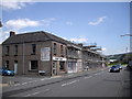
5
Port Talbot : Green Park Street
Green Park Street seen off of Water Street.
Image: © Lewis Clarke
Taken: 23 Jul 2017
0.09 miles
7
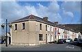
Beach Street, Port Talbot
Houses on the west side of Beach Street viewed from Ysguthan Road.
Image: © Jaggery
Taken: 8 Mar 2012
0.12 miles
8
North bank of the Afon Afan, Port Talbot
Viewed from the edge of Dock Road. The A4241 road bridge over the river is at the left edge of the view.
Image: © Jaggery
Taken: 8 Mar 2012
0.12 miles
9
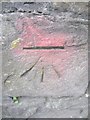
Ordnance Survey Cut Mark
This OS cut mark can be found on the wall of St Joseph's School, to the NW of Water Street. It marks a point 6.815m above mean sea level.
Image: © Adrian Dust
Taken: 22 Mar 2014
0.13 miles
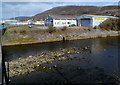
10
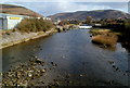
Weir in the Afon Afan, Port Talbot
A view upstream from the A4241 bridge.
The location of the weir in the middle distance is shown by the white water tumbling over it.
Image: © Jaggery
Taken: 8 Mar 2012
0.13 miles