IMAGES TAKEN NEAR TO
Sunny Road, PORT TALBOT, SA12 6JD
Introduction
This page details the photographs taken nearby to Sunny Road, SA12 6JD by members of the Geograph project.
The Geograph project started in 2005 with the aim of publishing, organising and preserving representative images for every square kilometre of Great Britain, Ireland and the Isle of Man.

There are currently over 7.5m images from over14,400 individuals and you can help contribute to the project by visiting https://www.geograph.org.uk
Image Map (Loading...)


Getting Data...Please wait
Leaflet Map data © OpenStreetMap
Images are licensed for reuse under creativecommons.org/licenses/by-sa/2.0
Notes
- Clicking on the map will re-center to the selected point.
- The higher the marker number, the further away the image location is from the centre of the postcode.
Image Listing (26 Images Found)
Images are licensed for reuse under creativecommons.org/licenses/by-sa/2.0
Image
Details
Distance
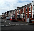
1
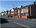
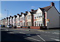
Victoria Road houses SW of Sandown Road, Port Talbot
The 20mph zone sign is on the corner of Sandown Road.
Image: © Jaggery
Taken: 8 Mar 2012
0.14 miles
2
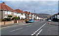
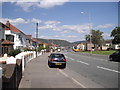
Victoria Road Port Talbot
Looking NE from the corner of Lake Road, Aberavon.
Image: © Jaggery
Taken: 8 Mar 2012
0.15 miles
3
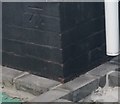
Ordnance Survey Cut Mark
This OS cut mark can be found on No61 Sandown Road. It marks a point 9.781m above mean sea level.
Image: © Adrian Dust
Taken: 4 May 2020
0.16 miles
4
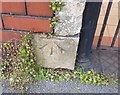
Ordnance Survey Cut Mark
This OS cut mark can be found on gatepost of No103 Victoria Road. It marks a point 8.486m above mean sea level.
Image: © Adrian Dust
Taken: 4 May 2020
0.17 miles
5
Victoria Road houses SW of Wheatley Avenue, Port Talbot
The 20mph zone sign is on the corner of Wheatley Avenue.
Image: © Jaggery
Taken: 8 Mar 2012
0.17 miles
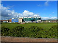
7
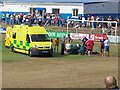
The Remax Stadium
(Formerly known as Victoria Road)
The home ground of Port Talbot Town A.F.C.
The photograph was taken at half-time during the pre-season friendly (for The Leanne Morris Memorial Shield) between Port Talbot Town and Newport County. An extended half-time interval resulted following an injury to Tony Pennock, the Newport County goalkeeper, who had to be taken to hospital.
Image: © David Luther Thomas
Taken: 22 Jul 2006
0.18 miles
8
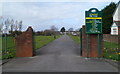
Southern entrance to Vivian Park, Port Talbot
From Moorland Road, opposite the Wheatley Avenue junction.
Image: © Jaggery
Taken: 8 Mar 2012
0.19 miles
10
St Paul's Road, Port Talbot
Looking SW from the junction with Hospital Road and Adare Street. The sign on the right near ground level shows the street name in English and Welsh. Above it, the older sign on the wall is in English only.
Image: © Jaggery
Taken: 8 Mar 2012
0.19 miles