IMAGES TAKEN NEAR TO
Pendarvis Terrace, PORT TALBOT, SA12 6DX
Introduction
This page details the photographs taken nearby to Pendarvis Terrace, SA12 6DX by members of the Geograph project.
The Geograph project started in 2005 with the aim of publishing, organising and preserving representative images for every square kilometre of Great Britain, Ireland and the Isle of Man.

There are currently over 7.5m images from over14,400 individuals and you can help contribute to the project by visiting https://www.geograph.org.uk
Image Map
Images are licensed for reuse under creativecommons.org/licenses/by-sa/2.0
Notes
- Clicking on the map will re-center to the selected point.
- The higher the marker number, the further away the image location is from the centre of the postcode.
Image Listing (52 Images Found)
Images are licensed for reuse under creativecommons.org/licenses/by-sa/2.0
Image
Details
Distance
1
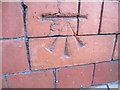
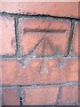
Ordnance Survey Cut Mark
This OS cut mark can be found on the school building to the NE of Pendarvis Terrace, opposite No19. It marks a point 7.983m above mean sea level.
Image: © Adrian Dust
Taken: 22 Mar 2014
0.02 miles
2
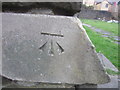
Ordnance Survey Cut Mark
This OS cut mark can be found on the NW side of St Paul's Church. It marks a point 7.983m above mean sea level.
Image: © Adrian Dust
Taken: 22 Mar 2014
0.03 miles
3
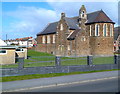
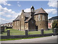
St Paul's church, Port Talbot
Viewed across Victoria Road. The Church in Wales church is on the corner of Pendarvis Terrace.
Image: © Jaggery
Taken: 8 Mar 2012
0.04 miles
4
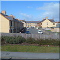
Gerald Street, Port Talbot
Viewed across Victoria Road from this http://www.geograph.org.uk/photo/3381574 footbridge.
Image: © Jaggery
Taken: 8 Mar 2012
0.04 miles
5
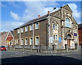
Corner view of Bethlehem Evangelical Church, Port Talbot
The church is at 30 Ysguthan Road, on the corner of Pendarvis Terrace.
The year 1914 in inscribed on the arch over the doorway.
http://www.geograph.org.uk/photo/3381470 to another view.
Image: © Jaggery
Taken: 8 Mar 2012
0.05 miles
7
Ordnance Survey Cut Mark
This OS cut mark can be found on the brick pillar at the junction of Pendarvis Terrace & Lilian Street. It marks a point 7.239m above mean sea level.
Image: © Adrian Dust
Taken: 22 Mar 2014
0.05 miles
8
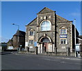
Bethlehem Evangelical Church, Port Talbot
The church is at 30 Ysguthan Road, on the corner of Pendarvis Terrace.
The year 1914 in inscribed on the arch over the doorway.
http://www.geograph.org.uk/photo/3381542 to a corner view
Image: © Jaggery
Taken: 8 Mar 2012
0.06 miles
9
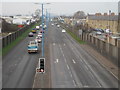
Aberavon Seaside railway station (site), Glamorgan
Opened in 1899 by the Rhondda & Swansea Bay Railway on the line from Treherbert to Swansea Riverside, this station closed in 1962.
View north west (at this point) towards Baglan Sands and Swansea. The track-bed later became the A4241. The main building was approximately where the road sign on the right now is.
Image: © Nigel Thompson
Taken: 27 Jan 2017
0.06 miles
10
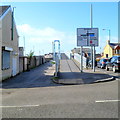
Eastern end of a footbridge across Afan Road, Port Talbot
A view of the footbridge http://www.geograph.org.uk/photo/3381574 from Victoria Road at the corner of Glyn Street.
Image: © Jaggery
Taken: 8 Mar 2012
0.07 miles