IMAGES TAKEN NEAR TO
Castle Street, PORT TALBOT, SA12 6DS
Introduction
This page details the photographs taken nearby to Castle Street, SA12 6DS by members of the Geograph project.
The Geograph project started in 2005 with the aim of publishing, organising and preserving representative images for every square kilometre of Great Britain, Ireland and the Isle of Man.

There are currently over 7.5m images from over14,400 individuals and you can help contribute to the project by visiting https://www.geograph.org.uk
Image Map
Images are licensed for reuse under creativecommons.org/licenses/by-sa/2.0
Notes
- Clicking on the map will re-center to the selected point.
- The higher the marker number, the further away the image location is from the centre of the postcode.
Image Listing (63 Images Found)
Images are licensed for reuse under creativecommons.org/licenses/by-sa/2.0
Image
Details
Distance


5
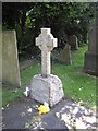
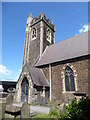
The grave of Dic Penderyn
St Mary's churchyard,Aberavon. Dic Penderyn (Richard Lewis) was executed at Cardiff in 1831, aged 23, for the part he played in the industrial riot at Merthyr Tydfil in June 1831.
Image: © John Lord
Taken: 14 Jul 2011
0.07 miles


10
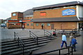
Market Tavern, Port Talbot
The pub is located at the southern edge of the Aberafan (shopping) Centre.
Image: © Jaggery
Taken: 8 Mar 2012
0.08 miles