IMAGES TAKEN NEAR TO
Kings Dock, SWANSEA, SA1 1QR
Introduction
This page details the photographs taken nearby to Kings Dock, SA1 1QR by members of the Geograph project.
The Geograph project started in 2005 with the aim of publishing, organising and preserving representative images for every square kilometre of Great Britain, Ireland and the Isle of Man.

There are currently over 7.5m images from over14,400 individuals and you can help contribute to the project by visiting https://www.geograph.org.uk
Image Map
Images are licensed for reuse under creativecommons.org/licenses/by-sa/2.0
Notes
- Clicking on the map will re-center to the selected point.
- The higher the marker number, the further away the image location is from the centre of the postcode.
Image Listing (5 Images Found)
Images are licensed for reuse under creativecommons.org/licenses/by-sa/2.0
Image
Details
Distance
1
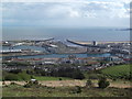
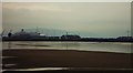
Swansea Docks
This photo is taken from the top of Kilvey Hill and clearly shows the change of use of Swansea Docks. Once a thriving dock with ships arriving and departing from all over the world, many of the older buildings have now been cleared and are being replaced by non dock related commercial enterprises and residential buildings. The area has been made more marketable by the development of the Tawe Barrage.
Image: © Kevin Corcoran
Taken: 15 May 2013
0.11 miles
2
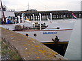
Bad teithwyr Balmoral / Balmoral pleasure cruiser
Bad teithwyr y Balmoral ar fin gadael Dociau Abertawe am Ynys Wair via Ilfracombe.
The Balmoral pleasure cruiser about to leave Swansea Docks for Lundy via Ilfracombe.
Image: © Alan Richards
Taken: 23 Aug 2011
0.14 miles
4
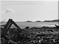
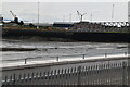
Flotsam and Jetsam
Some debris caught up as a result of one of the highest tides in the area in living memory... and this location gets the second highest tidal reach in the world!
Image: © Hywel Williams
Taken: 12 Sep 2010
0.19 miles