IMAGES TAKEN NEAR TO
Ystradfellte Road, NEATH, SA11 5UL
Introduction
This page details the photographs taken nearby to Ystradfellte Road, SA11 5UL by members of the Geograph project.
The Geograph project started in 2005 with the aim of publishing, organising and preserving representative images for every square kilometre of Great Britain, Ireland and the Isle of Man.

There are currently over 7.5m images from over14,400 individuals and you can help contribute to the project by visiting https://www.geograph.org.uk
Image Map (Loading...)


Getting Data...Please wait
Leaflet Map data © OpenStreetMap
Images are licensed for reuse under creativecommons.org/licenses/by-sa/2.0
Notes
- Clicking on the map will re-center to the selected point.
- The higher the marker number, the further away the image location is from the centre of the postcode.
Image Listing (54 Images Found)
Images are licensed for reuse under creativecommons.org/licenses/by-sa/2.0
Image
Details
Distance
1
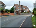
20 mph zone ahead, Pontneddfechan
Viewed from near the corner of Vale View. http://www.geograph.org.uk/photo/3103749 The school around the corner http://www.geograph.org.uk/photo/3103760 has been closed since July 2008, but the 20 mph speed limit zone has remained.
Image: © Jaggery
Taken: 7 Aug 2011
0.01 miles
2
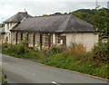
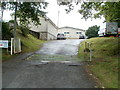
Former school, Pontneddfechan
This was a primary school, Ysgol Thomas Stephens.
It closed down at the end of the school year in July 2008.
Image: © Jaggery
Taken: 7 Aug 2011
0.04 miles
3
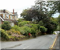
Postbox in a potentially dangerous location, Pontneddfechan
The postbox on a stand is located on the side of the road without a pavement, and where vehicles descend the hill. Perhaps the apparently safer location on the pavement opposite was not used because there are no houses nearby on that side.
Image: © Jaggery
Taken: 7 Aug 2011
0.06 miles
4
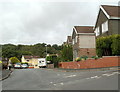
Vale View, Pontneddfechan
Vale View is a cul-de-sac on the east bank of the River Neath.
Image: © Jaggery
Taken: 7 Aug 2011
0.07 miles
5
Cattle grid across the entrance to Glynneath Golf Club, Pontneddfechan
In this location, sheep are the mostly likely straying animal that the grid prevents passing across.
The entrance http://www.geograph.org.uk/photo/3103802 is in the north of Pontneddfechan.
Image: © Jaggery
Taken: 7 Aug 2011
0.10 miles
6
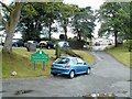
Entrance to Glynneath Golf Club, Pontneddfechan
Viewed from the road to Ystradfellte, in the north of Pontneddfechan.
Information on the green welcome sign shows:
18 hole course; junior course; golf professional; coffee shop;
licensed bar; meals available; visitors welcome.
Image: © Jaggery
Taken: 7 Aug 2011
0.10 miles
7
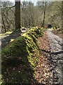
Woodland Track and Bank
When the railway track from the silica mines was constructed a shallow cutting was made creating this woodland bank. A good example of how land naturalises after man's disturbance.
Image: © Alan Hughes
Taken: 24 Mar 2017
0.12 miles
8
Houses opposite Abermellte Court, Pontneddfechan
Viewed from the edge of Abermellte Court. http://www.geograph.org.uk/photo/3103733
Image: © Jaggery
Taken: 7 Aug 2011
0.12 miles
9
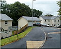
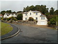
Abermellte Court houses, Pontneddfechan
Abermellte Court is a small cul-de-sac of 4 recently-built houses.
Image: © Jaggery
Taken: 7 Aug 2011
0.12 miles
10
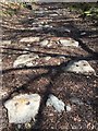
Railway Track
All that remains of the railway track which ran alongside Nedd Fechan are the stone footings showing the circular holes where the track brackets were secured.
Image: © Alan Hughes
Taken: 24 Mar 2017
0.13 miles