IMAGES TAKEN NEAR TO
Pont Nedd Fechan, NEATH, SA11 5UE
Introduction
This page details the photographs taken nearby to SA11 5UE by members of the Geograph project.
The Geograph project started in 2005 with the aim of publishing, organising and preserving representative images for every square kilometre of Great Britain, Ireland and the Isle of Man.

There are currently over 7.5m images from over14,400 individuals and you can help contribute to the project by visiting https://www.geograph.org.uk
Image Map (Loading...)


Getting Data...Please wait
Leaflet Map data © OpenStreetMap
Images are licensed for reuse under creativecommons.org/licenses/by-sa/2.0
Notes
- Clicking on the map will re-center to the selected point.
- The higher the marker number, the further away the image location is from the centre of the postcode.
Image Listing (45 Images Found)
Images are licensed for reuse under creativecommons.org/licenses/by-sa/2.0
Image
Details
Distance
1
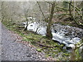
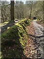
Part of the Afon Nedd Fechan
A beautiful section of riverside walking with lots to see; river birds, the remnants of industrial heritage and trees, mosses and lichens. The river forms the county boundary between Powys and Neath county borough.
Image: © Jeremy Bolwell
Taken: 22 Jan 2012
0.04 miles

3
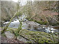
Bend on the Afon Nedd Fechan
A revetment for a tramroad or rail bridge remains on the far bank - just one example of lots of industrial remains that can be spotted on the Waterfalls Walk.
Image: © Jeremy Bolwell
Taken: 22 Jan 2012
0.05 miles
4
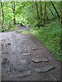
Former tramroad sleeper blocks in path beside the Nedd Fechan
Image: © Gareth James
Taken: 7 Aug 2011
0.06 miles
5
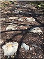
Railway Track
All that remains of the railway track which ran alongside Nedd Fechan are the stone footings showing the circular holes where the track brackets were secured.
Image: © Alan Hughes
Taken: 24 Mar 2017
0.07 miles
6
Woodland Track and Bank
When the railway track from the silica mines was constructed a shallow cutting was made creating this woodland bank. A good example of how land naturalises after man's disturbance.
Image: © Alan Hughes
Taken: 24 Mar 2017
0.08 miles
7
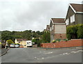
Vale View, Pontneddfechan
Vale View is a cul-de-sac on the east bank of the River Neath.
Image: © Jaggery
Taken: 7 Aug 2011
0.12 miles
8
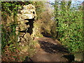
Farewell Rock
A popular path starts up beside the Nedd Fechan from behind the Angel Inn. It was originally cut into the sheer sides of the gorge to accommodate a tramway to bring 'silica rock' - a particularly pure sandstone suitable for the manufacture of refractory bricks - down from the various mines further up the valley. However the rock outcrop here is an example of another thick bed of sandstone known as the 'Farewell Rock' which marks the very base of the South Wales Coal Measures. Mining below it was fruitless, as no further ironstone or coal seams would be encountered - 'farewell' to useful mining - hence the colourful name.
Image: © Alan Bowring
Taken: 9 Feb 2008
0.13 miles
9
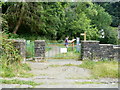
Southern entrance to Sgwd Gwladys walk, Pontneddfechan
The entrance gates are a few tens of metres behind these High Street houses. http://www.geograph.org.uk/photo/2547562
The walk leads to a series of majestic waterfalls in the upper valley of the River Neath, including Sgwd Gwladys waterfall http://www.geograph.org.uk/photo/1643466. Two walkers are studying a display map of the area.
Image: © Jaggery
Taken: 31 Jul 2011
0.14 miles
10
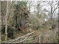
Remnant of a ruined building beside the Afon Nedd Fechan
Its historical use is hard to guess but its gable end looks precarious.
Image: © Jeremy Bolwell
Taken: 22 Jan 2012
0.17 miles