IMAGES TAKEN NEAR TO
Heol Wenallt, NEATH, SA11 5PZ
Introduction
This page details the photographs taken nearby to Heol Wenallt, SA11 5PZ by members of the Geograph project.
The Geograph project started in 2005 with the aim of publishing, organising and preserving representative images for every square kilometre of Great Britain, Ireland and the Isle of Man.

There are currently over 7.5m images from over14,400 individuals and you can help contribute to the project by visiting https://www.geograph.org.uk
Image Map
Images are licensed for reuse under creativecommons.org/licenses/by-sa/2.0
Notes
- Clicking on the map will re-center to the selected point.
- The higher the marker number, the further away the image location is from the centre of the postcode.
Image Listing (61 Images Found)
Images are licensed for reuse under creativecommons.org/licenses/by-sa/2.0
Image
Details
Distance
1
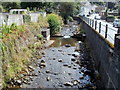
Nant Gwrach flows towards High Street, Cwmgwrach
The view upstream from the corner of High Street and Cefn Gelli. The road on the right is Heol Wenallt. After flowing under High Street, the stream enters the River Neath about 600 metres away.
Image: © Jaggery
Taken: 7 Aug 2011
0.03 miles
2
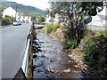
Nant Gwrach, Cwmgwrach
Nant Gwrach flows alongside Heol Wenallt. The stream is a tributary of the River Neath, which it enters about 600 metres NW of here.
Image: © Jaggery
Taken: 7 Aug 2011
0.03 miles
3

Nant Gwrach, Cwmgwrach
A stream, Nant Gwrach, flows away from High Street, near the corner of Cefn Gelli.
It is a tributary of the River Neath, which it enters about 600 metres ahead.
Image: © Jaggery
Taken: 7 Aug 2011
0.03 miles
4
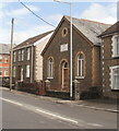
Calfaria Baptist Chapel, Cwmgwrach
Located on High Street. The inscription above the doorway, in Welsh, is
CALFARIA
CAPEL Y BEDYDDWYR
ADEILADWYD 1905
The translation is Calvary Baptist Chapel built 1905.
Image: © Jaggery
Taken: 7 Aug 2011
0.03 miles
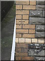
5
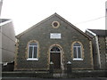
Calfaria Baptist Chapel
There is an Ordnance Survey cut mark on the north angle of the chapel. http://www.geograph.org.uk/photo/4308568
Image: © Adrian Dust
Taken: 11 Jan 2015
0.04 miles
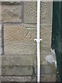
6
Ordnance Survey Cut Mark
This OS cut mark can be found on the NW face of the Baptist Chapel. It marks a point 55.638m above mean sea level. http://www.geograph.org.uk/photo/4308570
Image: © Adrian Dust
Taken: 11 Jan 2015
0.04 miles
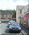
7
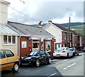
Cwmgwrach Post Office
Located on Dunraven Street, viewed from the corner of High Street.
Image: © Jaggery
Taken: 7 Aug 2011
0.04 miles
8
The Dunraven, Cwmgwrach
The village pub is on High Street, on the corner of Heol-y-felin.
Some sources refer to the 'Dunraven Arms' but there is currently no 'Arms' on the name signs.
Image: © Jaggery
Taken: 7 Aug 2011
0.05 miles
9
Ordnance Survey Cut Mark
This OS cut mark can be found on the SE face of Blaengwrach School. It marks a point 58.890m above mean sea level.
Image: © Adrian Dust
Taken: 11 Jan 2015
0.05 miles
10
Village post office and village shop, Cwmgwrach
This view along Dunraven Street towards High Street shows two of the main services in the village. Two others, the pub http://www.geograph.org.uk/photo/2542377 and a church http://www.geograph.org.uk/photo/2542337 are nearby, in High Street.
Image: © Jaggery
Taken: 7 Aug 2011
0.06 miles