IMAGES TAKEN NEAR TO
Pentre Canol, NEATH, SA11 5NL
Introduction
This page details the photographs taken nearby to Pentre Canol, SA11 5NL by members of the Geograph project.
The Geograph project started in 2005 with the aim of publishing, organising and preserving representative images for every square kilometre of Great Britain, Ireland and the Isle of Man.

There are currently over 7.5m images from over14,400 individuals and you can help contribute to the project by visiting https://www.geograph.org.uk
Image Map (Loading...)


Getting Data...Please wait
Leaflet Map data © OpenStreetMap
Images are licensed for reuse under creativecommons.org/licenses/by-sa/2.0
Notes
- Clicking on the map will re-center to the selected point.
- The higher the marker number, the further away the image location is from the centre of the postcode.
Image Listing (60 Images Found)
Images are licensed for reuse under creativecommons.org/licenses/by-sa/2.0
Image
Details
Distance
1
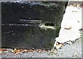
Ordnance Survey Cut Mark
This OS cut mark can be found on the west angle of the Dinas Hotel. It marks a point 81.174m above mean sea level.
Image: © Adrian Dust
Taken: 23 Oct 2016
0.03 miles
2
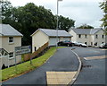
Abermellte Court houses, Pontneddfechan
Abermellte Court is a small cul-de-sac of 4 recently-built houses.
Image: © Jaggery
Taken: 7 Aug 2011
0.05 miles
3
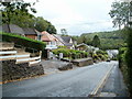
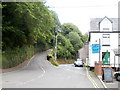
Descent towards the centre of Pontneddfechan
An unnamed, unclassified road heads towards Pontneathvaughan Road and High Street.
Image: © Jaggery
Taken: 7 Aug 2011
0.07 miles
4
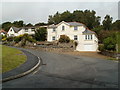
Houses opposite Abermellte Court, Pontneddfechan
Viewed from the edge of Abermellte Court. http://www.geograph.org.uk/photo/3103733
Image: © Jaggery
Taken: 7 Aug 2011
0.08 miles
5
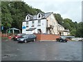
The Dinas Inn and car park, Pontneddfechan
Pub with accommodation available, viewed from Mellte Avenue. http://www.geograph.org.uk/photo/2519725
http://www.geograph.org.uk/photo/2519691 to a view along Pontneathvaughan Road.
Image: © Jaggery
Taken: 7 Aug 2011
0.08 miles
6

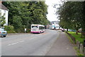
Veolia Beacons Bus, Pontneddfechan
A Veolia bus is on Brecon Beacons route B13, a circular route starting and ending in Brecon. Places on the route include Sennybridge, Crai, Ynyswen, Hirwaun, Penderyn and the (Brecon Beacons) National Park Visitor Centre.
The bus is scheduled to wait here, the Pontneathvaugan Road bus stop, for 10 minutes. Connections with the X5 service to and from Neath and Swansea can be made here.
Image: © Jaggery
Taken: 24 Jul 2011
0.08 miles
7
Road junction alongside the Dinas Inn, Pontneddfechan
On the right, Dinas Road passes the Dinas Inn. http://www.geograph.org.uk/photo/2519691
On the left is the road to Ystradfellte, Image 4½ miles away.
Image: © Jaggery
Taken: 24 Jul 2011
0.08 miles
8
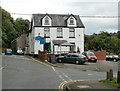
Dinas Inn, Pontneddfechan
Located on Dinas Road, facing the eastern end of Pontneathvaughan Road.
The Dinas is a pub and restaurant, with accommodation available.
http://www.geograph.org.uk/photo/2547440 to a view from Mellte Avenue.
Image: © Jaggery
Taken: 24 Jul 2011
0.08 miles
9
A First bus in Pontneddfechan
A First bus on route X5 from Neath heads along Pontneathvaughan Road. Its terminus and turning point is at the community centre on the eastern edge of the village.
The driver informed me that the X5 takes this route on Sundays only (presumably for the weekend tourists). On other days its terminus is at Pontwalby Bridge in Glynneath.
Image: © Jaggery
Taken: 31 Jul 2011
0.08 miles
10
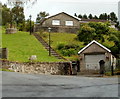
Hillside bungalow, Pontneddfechan
A flight of steps connects the bungalow with the road.
Image: © Jaggery
Taken: 7 Aug 2011
0.10 miles