IMAGES TAKEN NEAR TO
Glynneath, NEATH, SA11 5EP
Introduction
This page details the photographs taken nearby to SA11 5EP by members of the Geograph project.
The Geograph project started in 2005 with the aim of publishing, organising and preserving representative images for every square kilometre of Great Britain, Ireland and the Isle of Man.

There are currently over 7.5m images from over14,400 individuals and you can help contribute to the project by visiting https://www.geograph.org.uk
Image Map
Images are licensed for reuse under creativecommons.org/licenses/by-sa/2.0
Notes
- Clicking on the map will re-center to the selected point.
- The higher the marker number, the further away the image location is from the centre of the postcode.
Image Listing (30 Images Found)
Images are licensed for reuse under creativecommons.org/licenses/by-sa/2.0
Image
Details
Distance
1
Lamb and Flag Pub
Lamb and Flag Pub in Glynneath
Image: © David Gentle
Taken: 20 Oct 2005
0.00 miles
2
The Lamb and Flag
The Lamb and Flag, Glynneath.
Image: © Alan Hughes
Taken: 14 Mar 2016
0.01 miles
3

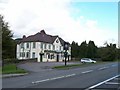
Glynneath : The Lamb and Flag viewed from the east
Early 19th-century inn located on the corner of the B4242 and Morfa Glas. The facilities available shown on the name board are "Pub and restaurant with guest rooms". So it's still an inn!
The Lamb and Flag was rebuilt after a devastating fire in November 2008. This http://www.geograph.org.uk/photo/612956 is how it looked in 2005.
http://www.geograph.org.uk/photo/2578398 to a view from the west.
Image: © Jaggery
Taken: 31 Jul 2011
0.02 miles
4

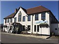
Glynneath : The Lamb and Flag viewed from the west
Early 19th-century inn located on the corner of the B4242 and Morfa Glas. The facilities available shown on the name board are "Pub and restaurant with guest rooms". So it's still an inn!
The Lamb and Flag was rebuilt after a devastating fire in November 2008. This http://www.geograph.org.uk/photo/612956 is how it looked in 2005.
http://www.geograph.org.uk/photo/2578421 to a view from the east.
Image: © Jaggery
Taken: 31 Jul 2011
0.02 miles
5
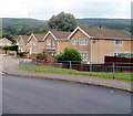
Roberts Close, Glynneath
Roberts Close is a short cul-de-sac on the north side of B4242, between the Lamb and Flag http://www.geograph.org.uk/photo/2578421 to the west and the ambulance station and fire station to the east.
Faintly visible on the hilltops are wind turbines.
Image: © Jaggery
Taken: 31 Jul 2011
0.04 miles
6
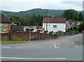
Morfa Glas, Glynneath
Viewed from the edge of the B4242. Morfa Glas is both the name of the road, and the area of Glynneath into which it is heading.
The Welsh words 'Morfa Glas' literally mean green (or blue) marsh. 'Glas' can mean blue or green, depending on context. It also means grey in some contexts. Confused? I am!
Image: © Jaggery
Taken: 31 Jul 2011
0.07 miles
7
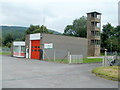
Glynneath Fire Station and tower
Located on the north side of Park Avenue, next to the Ambulance Station. http://www.geograph.org.uk/photo/2578460
The Fire Station is part of the Neath & Port Talbot County Command within the Mid and West Wales Fire and Rescue Service.
Image: © Jaggery
Taken: 31 Jul 2011
0.07 miles
8
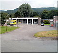
Glynneath Ambulance Station
Located on the north side of Park Avenue. The fire station http://www.geograph.org.uk/photo/2578477 is on the right.
Image: © Jaggery
Taken: 31 Jul 2011
0.07 miles
9
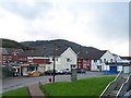
Lamb & Flag, Glynneath
Lamb & Flag area of Glynneath looking towards Pentre Street.
Image: © David Gentle
Taken: 20 Oct 2005
0.07 miles
10
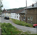
Mill Terrace, Glynneath
Mill Terrace is a row of 14 houses beyond the eastern end of Chain Walk.
Image: © Jaggery
Taken: 31 Jul 2011
0.08 miles