1
Llwybr ger Celliceubren / Path near Celliceubren
Llwybr cyhoeddus yn gadael Heol Celliceubren.
A public footpath exiting Heol Celliceibren (trans. hollow tree grove).
Image: © Alan Richards
Taken: 23 Jan 2019
0.08 miles
2
Llwybr tuag at yr ucheldir / Path to the high ground
Llwybr ceffyl yn dringo lan drwy'r blanhigfa goniferaidd tuag at yr ucheldir.
A bridleway ascending through the conifer plantation towards the high ground.
Image: © Alan Richards
Taken: 23 Jan 2019
0.14 miles
3
Pen-Machine Glynneath
The remains of Pen-Machine houses. The stone walls and foundations of seven cottages that were here which was called Pen-Machine. This location was also a junction of two tramways which descended to Glynneath. I would think that these dwelling were occupied by the miners.
Image: © Stephen Rees
Taken: 5 May 2020
0.16 miles
4
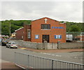
Peniel Pentecostal Church, Glynneath
Located on the corner of New Street and Lancaster Close. The church was opened in 1960.
Image: © Jaggery
Taken: 26 May 2010
0.17 miles
5
Crown Inn, Glynneath
High Street pub on the corner of Lancaster Close.
Image: © Jaggery
Taken: 31 Jul 2011
0.17 miles
6
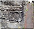
Ordnance Survey Cut Mark
This OS cut mark can be found on the wall of No11 High Street. It marks a point 185.0ft above mean sea level.
Image: © Adrian Dust
Taken: 28 May 2020
0.20 miles
7
Earlsfield Close, Glynneath
These are four of the eight houses in a cul-de-sac on the north side of Park Avenue (B4242).
Image: © Jaggery
Taken: 31 Jul 2011
0.20 miles
8
Park Avenue, Glynneath
Houses on Park Avenue, a continuation west from the end of High Street.
Image: © Jaggery
Taken: 26 May 2010
0.20 miles
9
Glynneath Public Library
Part of Neath Port Talbot County Borough's library service. The library's address is Park Avenue, Glynneath though it is located about 50 metres along an unnamed side road. There is a library sign on the corner of Park Avenue pointing visitors in the right direction.
Image: © Jaggery
Taken: 31 Jul 2011
0.20 miles
10
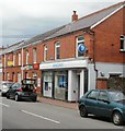
Barclays Bank and post office, Glynneath
Barclays Bank, 43 High Street, Glynneath is next door to the post office, number 41.
Image: © Jaggery
Taken: 26 May 2010
0.21 miles


