IMAGES TAKEN NEAR TO
School Place, NEATH, SA11 5DD
Introduction
This page details the photographs taken nearby to School Place, SA11 5DD by members of the Geograph project.
The Geograph project started in 2005 with the aim of publishing, organising and preserving representative images for every square kilometre of Great Britain, Ireland and the Isle of Man.

There are currently over 7.5m images from over14,400 individuals and you can help contribute to the project by visiting https://www.geograph.org.uk
Image Map
Images are licensed for reuse under creativecommons.org/licenses/by-sa/2.0
Notes
- Clicking on the map will re-center to the selected point.
- The higher the marker number, the further away the image location is from the centre of the postcode.
Image Listing (61 Images Found)
Images are licensed for reuse under creativecommons.org/licenses/by-sa/2.0
Image
Details
Distance
1
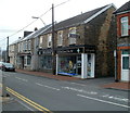
High Street pharmacy, Glynneath
Premises of D.R. Cecil Jones & Son Ltd at 101 High Street.
Image: © Jaggery
Taken: 31 Jul 2011
0.03 miles
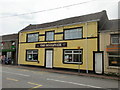
2
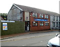
Glynneath Social Club
Located on the south side of High Street, a few metres from Bethel Baptist chapel. http://www.geograph.org.uk/photo/1882185
Image: © Jaggery
Taken: 4 Sep 2011
0.03 miles
3
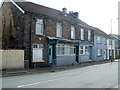
Lee's Garden, Glynneath
Chinese takeaway on High Street (B4242), to the east of Glynneath Social Club. http://www.geograph.org.uk/photo/2586044
Image: © Jaggery
Taken: 4 Sep 2011
0.03 miles
4
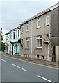
High Street houses, Glynneath
Houses on the south side of High Street, between Lee's Garden Chinese takeaway http://www.geograph.org.uk/photo/2586094 and the corner of Bethel Road (ahead).
Image: © Jaggery
Taken: 31 Jul 2011
0.03 miles
5
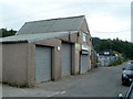
Neath Vale Building & DIY Supplies Ltd, Glynneath
Bethel Road premises on the north bank of the River Neath. Products and services advertised on the wall include key cutting, bottled gas, paraffin, timber, plywood, grow bags and compost.
Image: © Jaggery
Taken: 31 Jul 2011
0.03 miles
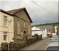
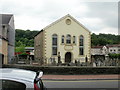
6
Bethel Baptist Chapel
Bethel Baptist Chapel, Glynneath.
Image: © Alan Hughes
Taken: 25 Mar 2016
0.04 miles
8
Bethany Presbyterian Church, Glynneath
Located on Bethania Street. Built in 1856 as Bethania Presbyterian Chapel, rebuilt 1867.
Image: © Jaggery
Taken: 26 May 2010
0.05 miles
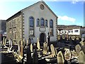
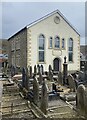
9
Bethel Baptist Chapel, High Street, Glynneath
Chapel located on the south side of High Street, a few metres east of the Heathfield Avenue junction.
The chapel is set back from the road, behind the graveyard. The inscription on the facade states that the chapel was erected 1846, reerected 1878.
Image: © Jaggery
Taken: 26 May 2010
0.05 miles
10
The Woolpack, Glynneath
Pub at 68 High Street.
On the right is Rohima takeaway. http://www.geograph.org.uk/photo/2578901
Image: © Jaggery
Taken: 26 May 2010
0.05 miles