IMAGES TAKEN NEAR TO
Rugby Road, NEATH, SA11 4HH
Introduction
This page details the photographs taken nearby to Rugby Road, SA11 4HH by members of the Geograph project.
The Geograph project started in 2005 with the aim of publishing, organising and preserving representative images for every square kilometre of Great Britain, Ireland and the Isle of Man.

There are currently over 7.5m images from over14,400 individuals and you can help contribute to the project by visiting https://www.geograph.org.uk
Image Map
Images are licensed for reuse under creativecommons.org/licenses/by-sa/2.0
Notes
- Clicking on the map will re-center to the selected point.
- The higher the marker number, the further away the image location is from the centre of the postcode.
Image Listing (59 Images Found)
Images are licensed for reuse under creativecommons.org/licenses/by-sa/2.0
Image
Details
Distance
1
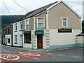
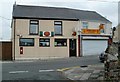
Shaan Tandoori Restaurant, Resolven
Located at 21 Commercial Road.
Image: © Jaggery
Taken: 31 Jul 2011
0.04 miles
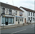
2
Millenium Rail Ltd, Resolven
Premises at 25 Commercial Road, opposite Cory Street.
The business's name is missing an 'n' from the usual spelling of millennium. The 'rail' part of the name is a mystery, as various online references show that this is a recruitment agency. Recruiting only railway workers would probably be overly restrictive in the small village of Resolven...
Image: © Jaggery
Taken: 31 Jul 2011
0.04 miles
3
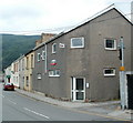
Railway Terrace, Resolven
The houses face a railway line, now used only for freight. Passenger services ended, and Resolven railway station closed, in 1964.
Image: © Jaggery
Taken: 31 Jul 2011
0.06 miles
4
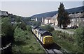
Coal empties for Cwmgwrach
Heading up the valley , the vale of Neath , a train of empty coal hoppers for the loading site at Cwmgwrach is pictured. The train is passing the former Resolven station site opened in 1851 and shut to passengers way back on the 21 March 1964. The line survived to move coal , however the trains are few and far between these days and it can be a very long wait to photograph movements on the line. Gritstone has also been moved in trains From Cwmgwrach on occasions.
Image: © roger geach
Taken: 15 May 1996
0.07 miles
5
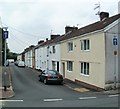
Resolven Post Office
Located at 14 Commercial Road. Next door is Golden Star, a takeaway selling Chinese and English food.
Image: © Jaggery
Taken: 31 Jul 2011
0.08 miles
6
Fish & chip shop for sale, Resolven
An estate agent's notice on 10 Commercial Road offers the property and business for sale.
Image: © Jaggery
Taken: 31 Jul 2011
0.08 miles
7
Resolven Health Centre
Located on Ynys Fach Avenue, on the west bank of Clydach Brook.
Image: © Jaggery
Taken: 31 Jul 2011
0.09 miles
8
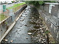
Clydach Brook, Resolven
The brook here flows between Resolven Health Centre http://www.geograph.org.uk/photo/2531871 and Clydach Avenue. http://www.geograph.org.uk/photo/2531902
The brook is a tributary of the River Neath, into which it flows about 300 metres behind the camera.
Image: © Jaggery
Taken: 31 Jul 2011
0.09 miles
9
Clydach Avenue, Resolven
Viewed from the corner of Ynys Fach Avenue. Out of shot on the right is Clydach Brook. http://www.geograph.org.uk/photo/2531891
Image: © Jaggery
Taken: 31 Jul 2011
0.09 miles
10
Corner of Ynys Fach Avenue and Clydach Avenue, Resolven
The right turn is into Clydach Avenue. http://www.geograph.org.uk/photo/2531902
Image: © Jaggery
Taken: 31 Jul 2011
0.09 miles